Alto del Camarón geodata
Alto del Camarón (Guerrero) is a populated place; located in Mexico in America/Mexico_City (GMT-6) time zone. With population of 916 people, there are 9527 cities with bigger population in this country. Compared to other cities in Mexico, 88.2% of cities are located further ↑North; 58.2% of cities are located further →East and 75.1% of cities have higher elevation than Alto del Camarón. Note1


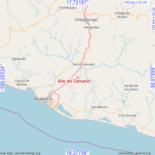
Alto del Camarón GPS coordinates[2]
17° 3' 3.492" North, 99° 34' 55.596" West
| Map corner | latitude | longitude |
|---|---|---|
| Upper-left | 17.72197°, | -100.28524° |
| Center: | 17.05097°, | -99.58211° |
| Lower-right: | 16.37756°, | -98.87899° |
| Map W x H: | 149.5×149.5 km | = 92.9×92.9mi |
| max Lat: | 32.7° ⇑88.2% North |
| Alto del Camarón: | 17.05097° |
| min Lat: | ⇓11.8% South 14.53588° |
| min Long | Alto del Camar� | max Long |
| -117.105° | -99.58211° | -86.73105° |
| W 41.8%⇐ | ⇒58.2% E |
Elevation
Elevation of Alto del Camarón is 220 m = 722 ft, and this is 1033.7 m = 3391 ft below average elevation for this country.
| Max E: |
3497 m = 11473 ft | 75.1% |
| Avg. | 1253.7 m = 4113 ft | |
| Alto del Camarón | 220 m = 722 ft | |
Min E: |
-1 m = -3 ft | 24.9% |
See also: Mexico elevation on elevation.city.
Geographical zone
Alto del Camarón is located in North Torrid zone (between Equator and Tropic of Cancer). Distance of this Northern Tropic circle is 710 km =441.2 mi to North.| Distance of | km | miles | from Alto del Camarón |
|---|---|---|---|
| North Pole | 8111.2 | 5040.1 | to North |
| Arctic Circle | 5505.3 | 3420.8 | to North |
| Tropic Cancer | 710 | 441.2 | to North |
| Equator | 1895.9 | 1178.1 | to South |


Nearby cities:
15 places around Alto del Camarón: (largest is in red/bold)
• Amatepec
11.1 km =6.9 mi,  134°
134°
• Apanhuac (Apanguaque)
15.3 km =9.5 mi,  182°
182°
• Chacalapa de Bravos
11.7 km =7.3 mi,  101°
101°
• Colonia Guerrero (Los Guajes)
3.5 km =2.2 mi,  250°
250°
• Dos Arroyos
7.9 km =4.9 mi,  244°
244°
• El Potrero Oriental
15.3 km =9.5 mi,  36°
36°
• La Palma
8.4 km =5.2 mi,  66°
66°
• Las Mesas
14 km =8.7 mi,  109°
109°
• Omitlán
10.8 km =6.7 mi,  47°
47°
• Palo Gordo
12.1 km =7.5 mi,  17°
17°
• Pueblo Madero (El Playón)
12.7 km =7.9 mi,  311°
311°
• Sabanillas
14 km =8.7 mi, 246°
• Tierra Colorada
14 km =8.7 mi, 24°
• Xaltianguis
15.1 km =9.4 mi,  290°
290°
• Xolapa
12.7 km =7.9 mi,  344°
344°
Sources, notices
• [Note1] Compared only with cities in Mexico existing in our database
• [Src1] Map data: © OpenStreetMap contributors (CC-BY-SA)
• [Src2] Other city data from geonames.org with taken over terms of usage.
• [Src3] Geographical zone / Annual Mean Temperature by Robert A. Rohde @ Wikipedia
