La Palma geodata
La Palma (Guerrero) is a populated place; located in Mexico in America/Mexico_City (GMT-6) time zone. With population of 1,597 people, there are 5413 cities with bigger population in this country. Compared to other cities in Mexico, 87.8% of cities are located further ↑North; 57.1% of cities are located further →East and 74.6% of cities have higher elevation than La Palma. Note1


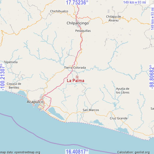
La Palma GPS coordinates[2]
17° 4' 53.328" North, 99° 30' 35.784" West
| Map corner | latitude | longitude |
|---|---|---|
| Upper-left | 17.75236°, | -100.21307° |
| Center: | 17.08148°, | -99.50994° |
| Lower-right: | 16.40817°, | -98.80682° |
| Map W x H: | 149.5×149.5 km | = 92.9×92.9mi |
| max Lat: | 32.7° ⇑87.8% North |
| La Palma: | 17.08148° |
| min Lat: | ⇓12.2% South 14.53588° |
| min Long | La Palma | max Long |
| -117.105° | -99.50994° | -86.73105° |
| W 42.9%⇐ | ⇒57.1% E |
Elevation
Elevation of La Palma is 232 m = 761 ft, and this is 1021.7 m = 3352 ft below average elevation for this country.
| Max E: |
3497 m = 11473 ft | 74.6% |
| Avg. | 1253.7 m = 4113 ft | |
| La Palma | 232 m = 761 ft | |
Min E: |
-1 m = -3 ft | 25.4% |
See also: Mexico elevation on elevation.city.
Geographical zone
La Palma is located in North Torrid zone (between Equator and Tropic of Cancer). Distance of this Northern Tropic circle is 706.6 km =439.1 mi to North.| Distance of | km | miles | from La Palma |
|---|---|---|---|
| North Pole | 8107.8 | 5038 | to North |
| Arctic Circle | 5501.9 | 3418.7 | to North |
| Tropic Cancer | 706.6 | 439.1 | to North |
| Equator | 1899.3 | 1180.2 | to South |


Nearby cities:
15 places around La Palma: (largest is in red/bold)
• Alto del Camarón
8.4 km =5.2 mi,  246°
246°
• Amatepec
11.2 km =7 mi,  178°
178°
• Chacalapa de Bravos
6.8 km =4.2 mi,  146°
146°
• Chautipa
12.7 km =7.9 mi,  84°
84°
• Colonia Guerrero (Los Guajes)
11.9 km =7.4 mi, 247°
• El Potrero Oriental
9 km =5.6 mi,  8°
8°
• El Puente
14.1 km =8.8 mi,  54°
54°
• Garrapatas (Garrapata)
12 km =7.5 mi,  355°
355°
• Las Cruces
13.9 km =8.6 mi, 150°
• Las Mesas
9.9 km =6.2 mi, 145°
• Omitlán
4 km =2.5 mi,  3°
3°
• Palo Gordo
9.1 km =5.7 mi,  333°
333°
• Pochotillo
11.1 km =6.9 mi,  127°
127°
• Rancho Viejo
11.8 km =7.3 mi, 82°
• Tierra Colorada
9.6 km =6 mi,  348°
348°
Sources, notices
• [Note1] Compared only with cities in Mexico existing in our database
• [Src1] Map data: © OpenStreetMap contributors (CC-BY-SA)
• [Src2] Other city data from geonames.org with taken over terms of usage.
• [Src3] Geographical zone / Annual Mean Temperature by Robert A. Rohde @ Wikipedia
