Las Mesas geodata
Las Mesas (Guerrero) is a populated place; located in Mexico in America/Mexico_City (GMT-6) time zone. With population of 2,692 people, there are 3289 cities with bigger population in this country. Compared to other cities in Mexico, 88.8% of cities are located further ↑North; 56.3% of cities are located further →East and 69.7% of cities have higher elevation than Las Mesas. Note1


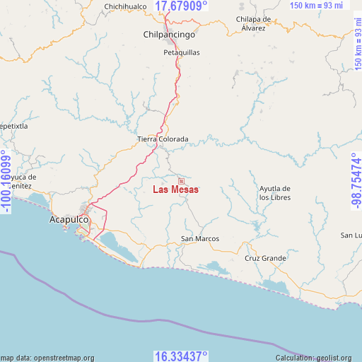
Las Mesas GPS coordinates[2]
17° 0' 28.584" North, 99° 27' 28.296" West
| Map corner | latitude | longitude |
|---|---|---|
| Upper-left | 17.67909°, | -100.16099° |
| Center: | 17.00794°, | -99.45786° |
| Lower-right: | 16.33437°, | -98.75474° |
| Map W x H: | 149.5×149.5 km | = 92.9×92.9mi |
| max Lat: | 32.7° ⇑88.8% North |
| Las Mesas: | 17.00794° |
| min Lat: | ⇓11.2% South 14.53588° |
| min Long | Las Mesas | max Long |
| -117.105° | -99.45786° | -86.73105° |
| W 43.7%⇐ | ⇒56.3% E |
Elevation
Elevation of Las Mesas is 429 m = 1407 ft, and this is 824.7 m = 2706 ft below average elevation for this country.
| Max E: |
3497 m = 11473 ft | 69.7% |
| Avg. | 1253.7 m = 4113 ft | |
| Las Mesas | 429 m = 1407 ft | |
Min E: |
-1 m = -3 ft | 30.3% |
See also: Mexico elevation on elevation.city.
Geographical zone
Las Mesas is located in North Torrid zone (between Equator and Tropic of Cancer). Distance of this Northern Tropic circle is 714.8 km =444.2 mi to North.| Distance of | km | miles | from Las Mesas |
|---|---|---|---|
| North Pole | 8116 | 5043 | to North |
| Arctic Circle | 5510.1 | 3423.8 | to North |
| Tropic Cancer | 714.8 | 444.2 | to North |
| Equator | 1891.1 | 1175.1 | to South |


Nearby cities:
15 places around Las Mesas: (largest is in red/bold)
• Alto del Camarón
14 km =8.7 mi,  289°
289°
• Amatepec
6.1 km =3.8 mi,  240°
240°
• Chacalapa de Bravos
3.1 km =1.9 mi,  325°
325°
• Chautipa
11.7 km =7.3 mi,  37°
37°
• El Limón
8.7 km =5.4 mi,  99°
99°
• La Palma
9.9 km =6.2 mi, 325°
• Las Cruces
4.1 km =2.5 mi,  160°
160°
• Llano Grande
8 km =5 mi, 161°
• Ocotlán
12.1 km =7.5 mi,  128°
128°
• Omitlán
13.2 km =8.2 mi,  336°
336°
• Piedra Blanca
12.1 km =7.5 mi,  202°
202°
• Pochotillo
3.6 km =2.2 mi,  66°
66°
• Rancho Nuevo
7.2 km =4.5 mi,  191°
191°
• Rancho Viejo
11.5 km =7.1 mi,  32°
32°
• Xalpatláhuac
13.6 km =8.5 mi,  82°
82°
Sources, notices
• [Note1] Compared only with cities in Mexico existing in our database
• [Src1] Map data: © OpenStreetMap contributors (CC-BY-SA)
• [Src2] Other city data from geonames.org with taken over terms of usage.
• [Src3] Geographical zone / Annual Mean Temperature by Robert A. Rohde @ Wikipedia
