Amatepec geodata
Amatepec (Guerrero) is a populated place; located in Mexico in America/Mexico_City (GMT-6) time zone. With population of 585 people, there are 14661 cities with bigger population in this country. Compared to other cities in Mexico, 89.1% of cities are located further ↑North; 57.1% of cities are located further →East and 71% of cities have higher elevation than Amatepec. Note1


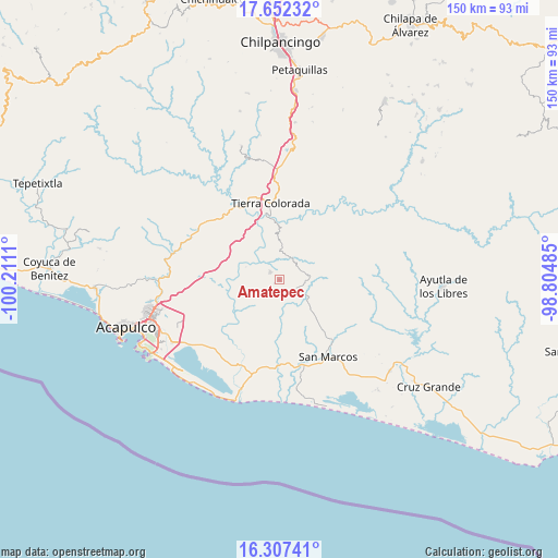
Amatepec GPS coordinates[2]
16° 58' 51.852" North, 99° 30' 28.692" West
| Map corner | latitude | longitude |
|---|---|---|
| Upper-left | 17.65232°, | -100.2111° |
| Center: | 16.98107°, | -99.50797° |
| Lower-right: | 16.30741°, | -98.80485° |
| Map W x H: | 149.5×149.5 km | = 92.9×92.9mi |
| max Lat: | 32.7° ⇑89.1% North |
| Amatepec: | 16.98107° |
| min Lat: | ⇓10.9% South 14.53588° |
| min Long | Amatepec | max Long |
| -117.105° | -99.50797° | -86.73105° |
| W 42.9%⇐ | ⇒57.1% E |
Elevation
Elevation of Amatepec is 371 m = 1217 ft, and this is 882.7 m = 2896 ft below average elevation for this country.
| Max E: |
3497 m = 11473 ft | 71% |
| Avg. | 1253.7 m = 4113 ft | |
| Amatepec | 371 m = 1217 ft | |
Min E: |
-1 m = -3 ft | 29% |
See also: Mexico elevation on elevation.city.
Geographical zone
Amatepec is located in North Torrid zone (between Equator and Tropic of Cancer). Distance of this Northern Tropic circle is 717.8 km =446 mi to North.| Distance of | km | miles | from Amatepec |
|---|---|---|---|
| North Pole | 8118.9 | 5044.8 | to North |
| Arctic Circle | 5513.1 | 3425.7 | to North |
| Tropic Cancer | 717.8 | 446 | to North |
| Equator | 1888.1 | 1173.2 | to South |


Nearby cities:
15 places around Amatepec: (largest is in red/bold)
• Alto del Camarón
11.1 km =6.9 mi,  314°
314°
• Apanhuac (Apanguaque)
11.4 km =7.1 mi,  228°
228°
• Barrio Nuevo de los Muertos
10.5 km =6.5 mi,  201°
201°
• Chacalapa de Bravos
6.6 km =4.1 mi,  33°
33°
• Colonia Guerrero (Los Guajes)
13 km =8.1 mi,  300°
300°
• El Cantón
13.6 km =8.5 mi,  224°
224°
• El Limón
14 km =8.7 mi,  83°
83°
• El Tamarindo
14.6 km =9.1 mi,  183°
183°
• La Palma
11.2 km =7 mi,  358°
358°
• Las Cruces
6.7 km =4.2 mi,  97°
97°
• Las Mesas
6.1 km =3.8 mi,  60°
60°
• Llano Grande
9.1 km =5.7 mi,  119°
119°
• Piedra Blanca
8.2 km =5.1 mi, 175°
• Pochotillo
9.7 km =6 mi, 62°
• Rancho Nuevo
5.6 km =3.5 mi,  136°
136°
Sources, notices
• [Note1] Compared only with cities in Mexico existing in our database
• [Src1] Map data: © OpenStreetMap contributors (CC-BY-SA)
• [Src2] Other city data from geonames.org with taken over terms of usage.
• [Src3] Geographical zone / Annual Mean Temperature by Robert A. Rohde @ Wikipedia
