San Miguel Almaya geodata
San Miguel Almaya (Morelos) is a populated place; located in Mexico in America/Mexico_City (GMT-6) time zone. With population of 4,941 people, there are 1869 cities with bigger population in this country. Compared to other cities in Mexico, 60.9% of cities are located further ↑North; 56.1% of cities are located further →East and 97.7% of cities have lower elevation than San Miguel Almaya. Note1


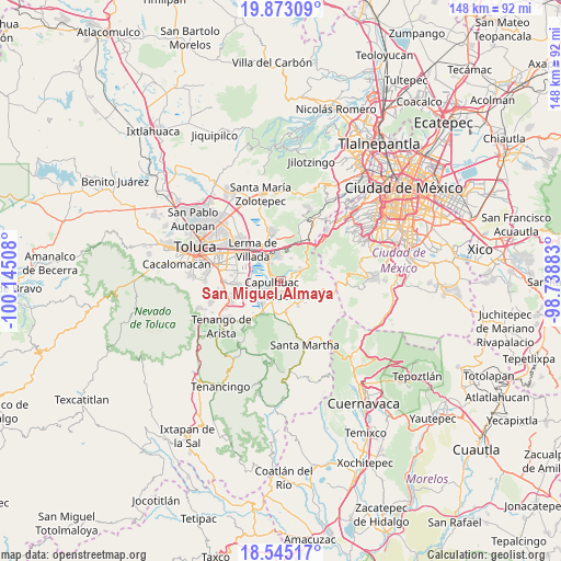
San Miguel Almaya GPS coordinates[2]
19° 12' 37.692" North, 99° 26' 31.02" West
| Map corner | latitude | longitude |
|---|---|---|
| Upper-left | 19.87309°, | -100.14508° |
| Center: | 19.21047°, | -99.44195° |
| Lower-right: | 18.54517°, | -98.73883° |
| Map W x H: | 147.7×147.7 km | = 91.8×91.8mi |
| max Lat: | 32.7° ⇑60.9% North |
| San Miguel Almaya: | 19.21047° |
| min Lat: | ⇓39.1% South 14.53588° |
| min Long | San Miguel Alma | max Long |
| -117.105° | -99.44195° | -86.73105° |
| W 43.9%⇐ | ⇒56.1% E |
Elevation
Elevation of San Miguel Almaya is 2726 m = 8944 ft, and this is 1472.3 m = 4830 ft above average elevation for this country.
| Max E: |
3497 m = 11473 ft | 2.3% |
| San Miguel Almaya | 2726 m 8944 ft | |
| Avg. | 1253.7 m = 4113 ft | |
Min E: |
-1 m = -3 ft | 97.7% |
See also: Mexico elevation on elevation.city.
Geographical zone
San Miguel Almaya is located in North Torrid zone (between Equator and Tropic of Cancer). Distance of this Northern Tropic circle is 469.9 km =292 mi to North.| Distance of | km | miles | from San Miguel Almaya |
|---|---|---|---|
| North Pole | 7871.1 | 4890.9 | to North |
| Arctic Circle | 5265.2 | 3271.6 | to North |
| Tropic Cancer | 469.9 | 292 | to North |
| Equator | 2136 | 1327.2 | to South |


Nearby cities:
15 places around San Miguel Almaya: (largest is in red/bold)
• Agua Blanca
3.2 km =2 mi,  290°
290°
• Capulhuac de Mirafuentes
3.1 km =1.9 mi,  233°
233°
• Coamilpa de Juárez
1.4 km =0.9 mi,  187°
187°
• Colonia las Granjas
3.5 km =2.2 mi,  195°
195°
• Guadalupe Victoria
3.1 km =1.9 mi,  37°
37°
• La Magdalena de los Reyes (La Magdalena)
4.1 km =2.5 mi,  124°
124°
• Lomas de San Juan
2.2 km =1.4 mi,  267°
267°
• Mezapa la Fábrica
3.9 km =2.4 mi, 185°
• San Felipe el Mirasol
2.4 km =1.5 mi,  111°
111°
• San Juan Bautista
1.9 km =1.2 mi,  236°
236°
• San Nicolás Tlazala
2.9 km =1.8 mi,  307°
307°
• Santa Cruz Tultepec
3.6 km =2.2 mi,  301°
301°
• Santa Cruz de Bravo (Santa Cruz)
3.3 km =2.1 mi, 109°
• Santiago Tílapa
3.2 km =2 mi,  136°
136°
• Xalatlaco
3.9 km =2.4 mi, 140°
Sources, notices
• [Note1] Compared only with cities in Mexico existing in our database
• [Src1] Map data: © OpenStreetMap contributors (CC-BY-SA)
• [Src2] Other city data from geonames.org with taken over terms of usage.
• [Src3] Geographical zone / Annual Mean Temperature by Robert A. Rohde @ Wikipedia
