Lomas de San Juan geodata
Lomas de San Juan (State of Mexico) is a populated place; located in Mexico in America/Mexico_City (GMT-6) time zone. With population of 917 people, there are 9514 cities with bigger population in this country. Compared to other cities in Mexico, 61% of cities are located further ↑North; 56.4% of cities are located further →East and 95.7% of cities have lower elevation than Lomas de San Juan. Note1


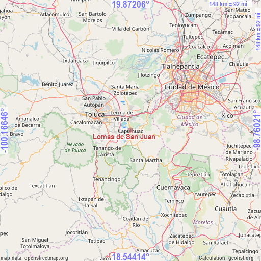
Lomas de San Juan GPS coordinates[2]
19° 12' 33.984" North, 99° 27' 47.988" West
| Map corner | latitude | longitude |
|---|---|---|
| Upper-left | 19.87206°, | -100.16646° |
| Center: | 19.20944°, | -99.46333° |
| Lower-right: | 18.54414°, | -98.76021° |
| Map W x H: | 147.7×147.7 km | = 91.8×91.8mi |
| max Lat: | 32.7° ⇑61% North |
| Lomas de San Juan: | 19.20944° |
| min Lat: | ⇓39% South 14.53588° |
| min Long | Lomas de San Ju | max Long |
| -117.105° | -99.46333° | -86.73105° |
| W 43.6%⇐ | ⇒56.4% E |
Elevation
Elevation of Lomas de San Juan is 2616 m = 8583 ft, and this is 1362.3 m = 4469 ft above average elevation for this country.
| Max E: |
3497 m = 11473 ft | 4.3% |
| Lomas de San Juan | 2616 m 8583 ft | |
| Avg. | 1253.7 m = 4113 ft | |
Min E: |
-1 m = -3 ft | 95.7% |
See also: Mexico elevation on elevation.city.
Geographical zone
Lomas de San Juan is located in North Torrid zone (between Equator and Tropic of Cancer). Distance of this Northern Tropic circle is 470 km =292 mi to North.| Distance of | km | miles | from Lomas de San Juan |
|---|---|---|---|
| North Pole | 7871.2 | 4890.9 | to North |
| Arctic Circle | 5265.3 | 3271.7 | to North |
| Tropic Cancer | 470 | 292 | to North |
| Equator | 2135.9 | 1327.2 | to South |


Nearby cities:
15 places around Lomas de San Juan: (largest is in red/bold)
• Agua Blanca
1.5 km =0.9 mi,  328°
328°
• Capulhuac de Mirafuentes
1.8 km =1.1 mi,  188°
188°
• Coamilpa de Juárez
2.4 km =1.5 mi,  122°
122°
• Colonia el Pirame
3.6 km =2.2 mi,  345°
345°
• Colonia la Poza
2 km =1.2 mi,  235°
235°
• Colonia las Granjas
3.5 km =2.2 mi,  158°
158°
• Mezapa la Fábrica
4.2 km =2.6 mi,  153°
153°
• San Felipe el Mirasol
4.5 km =2.8 mi,  99°
99°
• San Juan Bautista
1.2 km =0.7 mi,  142°
142°
• San Miguel Almaya
2.2 km =1.4 mi,  87°
87°
• San Nicolás Tlazala
1.9 km =1.2 mi,  358°
358°
• San Pedro Tlaltizapan
4 km =2.5 mi,  254°
254°
• Santa Cruz Atizapán
4.5 km =2.8 mi,  216°
216°
• Santa Cruz Tultepec
2.1 km =1.3 mi,  337°
337°
• Santiago Tianguistenco de Galeana
3.3 km =2.1 mi, 185°
Sources, notices
• [Note1] Compared only with cities in Mexico existing in our database
• [Src1] Map data: © OpenStreetMap contributors (CC-BY-SA)
• [Src2] Other city data from geonames.org with taken over terms of usage.
• [Src3] Geographical zone / Annual Mean Temperature by Robert A. Rohde @ Wikipedia
