Guadalupe Victoria geodata
Guadalupe Victoria (Morelos) is a populated place; located in Mexico in America/Mexico_City (GMT-6) time zone. With population of 863 people, there are 10137 cities with bigger population in this country. Compared to other cities in Mexico, 60.3% of cities are located further ↑North; 55.9% of cities are located further →East and 97.6% of cities have lower elevation than Guadalupe Victoria. Note1


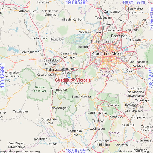
Guadalupe Victoria GPS coordinates[2]
19° 13' 57.936" North, 99° 25' 25.788" West
| Map corner | latitude | longitude |
|---|---|---|
| Upper-left | 19.89529°, | -100.12696° |
| Center: | 19.23276°, | -99.42383° |
| Lower-right: | 18.56755°, | -98.72071° |
| Map W x H: | 147.6×147.6 km | = 91.7×91.7mi |
| max Lat: | 32.7° ⇑60.3% North |
| Guadalupe Victoria: | 19.23276° |
| min Lat: | ⇓39.7% South 14.53588° |
| min Long | Guadalupe Victo | max Long |
| -117.105° | -99.42383° | -86.73105° |
| W 44.1%⇐ | ⇒55.9% E |
Elevation
Elevation of Guadalupe Victoria is 2717 m = 8914 ft, and this is 1463.3 m = 4801 ft above average elevation for this country.
| Max E: |
3497 m = 11473 ft | 2.4% |
| Guadalupe Victoria | 2717 m 8914 ft | |
| Avg. | 1253.7 m = 4113 ft | |
Min E: |
-1 m = -3 ft | 97.6% |
See also: Mexico elevation on elevation.city.
Geographical zone
Guadalupe Victoria is located in North Torrid zone (between Equator and Tropic of Cancer). Distance of this Northern Tropic circle is 467.4 km =290.4 mi to North.| Distance of | km | miles | from Guadalupe Victoria |
|---|---|---|---|
| North Pole | 7868.6 | 4889.3 | to North |
| Arctic Circle | 5262.7 | 3270.1 | to North |
| Tropic Cancer | 467.4 | 290.4 | to North |
| Equator | 2138.5 | 1328.8 | to South |


Nearby cities:
15 places around Guadalupe Victoria: (largest is in red/bold)
• Coamilpa de Juárez
4.4 km =2.7 mi,  208°
208°
• El Pedregal de Guadalupe Hidalgo
4.9 km =3 mi,  297°
297°
• La Magdalena de los Reyes (La Magdalena)
5 km =3.1 mi,  163°
163°
• Loma Bonita
4.2 km =2.6 mi,  324°
324°
• Loma de los Esquiveles
4.6 km =2.9 mi, 321°
• Lomas de San Juan
4.9 km =3 mi,  237°
237°
• San Felipe el Mirasol
3.4 km =2.1 mi,  175°
175°
• San Jerónimo Acazulco
3.7 km =2.3 mi,  12°
12°
• San Juan Bautista
4.9 km =3 mi,  224°
224°
• San Miguel Almaya
3.1 km =1.9 mi, 217°
• San Nicolás Tlazala
4.3 km =2.7 mi,  260°
260°
• San Pedro Atlapulco
3.3 km =2.1 mi,  67°
67°
• Santa Cruz de Bravo (Santa Cruz)
3.8 km =2.4 mi, 161°
• Santiago Tílapa
4.8 km =3 mi, 176°
• Texcalpa (Ex-Hacienda Texcalpa)
4.6 km =2.9 mi,  312°
312°
Sources, notices
• [Note1] Compared only with cities in Mexico existing in our database
• [Src1] Map data: © OpenStreetMap contributors (CC-BY-SA)
• [Src2] Other city data from geonames.org with taken over terms of usage.
• [Src3] Geographical zone / Annual Mean Temperature by Robert A. Rohde @ Wikipedia
