Ahuacatán geodata
Ahuacatán (Veracruz) is a populated place; located in Mexico in America/Mexico_City (GMT-6) time zone. With population of 1,579 people, there are 5470 cities with bigger population in this country. Compared to other cities in Mexico, 52.4% of cities are located further ↓South; 71.5% of cities are located further ←West and 71.5% of cities have lower elevation than Ahuacatán. Note1


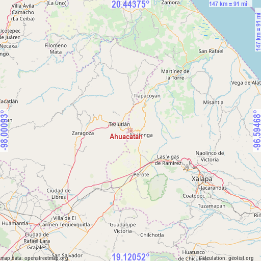
Ahuacatán GPS coordinates[2]
19° 47' 0.636" North, 97° 17' 52.08" West
| Map corner | latitude | longitude |
|---|---|---|
| Upper-left | 20.44375°, | -98.00093° |
| Center: | 19.78351°, | -97.2978° |
| Lower-right: | 19.12052°, | -96.59468° |
| Map W x H: | 147.1×147.1 km | = 91.4×91.4mi |
| max Lat: | 32.7° ⇑47.6% North |
| Ahuacatán: | 19.78351° |
| min Lat: | ⇓52.4% South 14.53588° |
| min Long | Ahuacatán | max Long |
| -117.105° | -97.2978° | -86.73105° |
| W 71.5%⇐ | ⇒28.5% E |
Elevation
Elevation of Ahuacatán is 1958 m = 6424 ft, and this is 704.3 m = 2311 ft above average elevation for this country.
| Max E: |
3497 m = 11473 ft | 28.5% |
| Ahuacatán | 1958 m 6424 ft | |
| Avg. | 1253.7 m = 4113 ft | |
Min E: |
-1 m = -3 ft | 71.5% |
See also: Mexico elevation on elevation.city.
Geographical zone
Ahuacatán is located in North Torrid zone (between Equator and Tropic of Cancer). Distance of this Northern Tropic circle is 406.2 km =252.4 mi to North.| Distance of | km | miles | from Ahuacatán |
|---|---|---|---|
| North Pole | 7807.3 | 4851.2 | to North |
| Arctic Circle | 5201.5 | 3232.1 | to North |
| Tropic Cancer | 406.2 | 252.4 | to North |
| Equator | 2199.7 | 1366.8 | to South |


Nearby cities:
15 places around Ahuacatán: (largest is in red/bold)
• Cuauhtamingo
2.7 km =1.7 mi,  219°
219°
• El Zapote
4 km =2.5 mi,  258°
258°
• Jalacingo
2.5 km =1.6 mi,  333°
333°
• Loma de Hidalgo
4 km =2.5 mi,  177°
177°
• Miguel Hidalgo
3.3 km =2.1 mi,  150°
150°
• Ocotepec
3.6 km =2.2 mi,  43°
43°
• San Andrés
4.4 km =2.7 mi,  279°
279°
• San Francisco
3.2 km =2 mi, 257°
• San José
4.4 km =2.7 mi,  299°
299°
• San Juan Xiutetelco
3.2 km =2 mi,  294°
294°
• San Martín
4.4 km =2.7 mi,  268°
268°
• Santiago
4.2 km =2.6 mi,  319°
319°
• Texacaxco
4.3 km =2.7 mi,  118°
118°
• Tomaquilapa
3.9 km =2.4 mi, 219°
• Xaltipan (Sección Décima)
4.9 km =3 mi,  240°
240°
Sources, notices
• [Note1] Compared only with cities in Mexico existing in our database
• [Src1] Map data: © OpenStreetMap contributors (CC-BY-SA)
• [Src2] Other city data from geonames.org with taken over terms of usage.
• [Src3] Geographical zone / Annual Mean Temperature by Robert A. Rohde @ Wikipedia
