Ocotepec geodata
Ocotepec (Puebla) is a populated place; located in Mexico in America/Mexico_City (GMT-6) time zone. With population of 2,453 people, there are 3603 cities with bigger population in this country. Compared to other cities in Mexico, 53% of cities are located further ↓South; 71.7% of cities are located further ←West and 66.1% of cities have lower elevation than Ocotepec. Note1


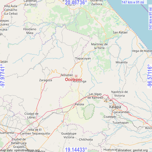
Ocotepec GPS coordinates[2]
19° 48' 25.992" North, 97° 16' 27.408" West
| Map corner | latitude | longitude |
|---|---|---|
| Upper-left | 20.46736°, | -97.97741° |
| Center: | 19.80722°, | -97.27428° |
| Lower-right: | 19.14433°, | -96.57116° |
| Map W x H: | 147.1×147.1 km | = 91.4×91.4mi |
| max Lat: | 32.7° ⇑47% North |
| Ocotepec: | 19.80722° |
| min Lat: | ⇓53% South 14.53588° |
| min Long | Ocotepec | max Long |
| -117.105° | -97.27428° | -86.73105° |
| W 71.7%⇐ | ⇒28.3% E |
Elevation
Elevation of Ocotepec is 1853 m = 6079 ft, and this is 599.3 m = 1966 ft above average elevation for this country.
| Max E: |
3497 m = 11473 ft | 33.9% |
| Ocotepec | 1853 m 6079 ft | |
| Avg. | 1253.7 m = 4113 ft | |
Min E: |
-1 m = -3 ft | 66.1% |
See also: Mexico elevation on elevation.city.
Geographical zone
Ocotepec is located in North Torrid zone (between Equator and Tropic of Cancer). Distance of this Northern Tropic circle is 403.6 km =250.8 mi to North.| Distance of | km | miles | from Ocotepec |
|---|---|---|---|
| North Pole | 7804.7 | 4849.6 | to North |
| Arctic Circle | 5198.8 | 3230.4 | to North |
| Tropic Cancer | 403.6 | 250.8 | to North |
| Equator | 2202.4 | 1368.5 | to South |


Nearby cities:
15 places around Ocotepec: (largest is in red/bold)
• Ahuacatán
3.6 km =2.2 mi,  223°
223°
• Altotonga
5.5 km =3.4 mi,  146°
146°
• Atzalan
4 km =2.5 mi,  121°
121°
• Cuauhtamingo
6.3 km =3.9 mi, 221°
• Ixtlahuaca
6.6 km =4.1 mi,  285°
285°
• Jalacingo
3.6 km =2.2 mi,  263°
263°
• La Florida
3.2 km =2 mi,  103°
103°
• Melchor Ocampo
5 km =3.1 mi,  316°
316°
• Miguel Hidalgo
5.6 km =3.5 mi,  188°
188°
• San Francisco
6.5 km =4 mi,  239°
239°
• San José
6.3 km =3.9 mi,  265°
265°
• San Juan Xiutetelco
5.5 km =3.4 mi, 256°
• San Salvador (Naranjillo)
5 km =3.1 mi,  302°
302°
• Santiago
5.2 km =3.2 mi,  275°
275°
• Texacaxco
4.9 km =3 mi,  164°
164°
Sources, notices
• [Note1] Compared only with cities in Mexico existing in our database
• [Src1] Map data: © OpenStreetMap contributors (CC-BY-SA)
• [Src2] Other city data from geonames.org with taken over terms of usage.
• [Src3] Geographical zone / Annual Mean Temperature by Robert A. Rohde @ Wikipedia
