Loma de Hidalgo geodata
Loma de Hidalgo (Veracruz) is a populated place; located in Mexico in America/Mexico_City (GMT-6) time zone. With population of 832 people, there are 10517 cities with bigger population in this country. Compared to other cities in Mexico, 51.5% of cities are located further ↓South; 71.6% of cities are located further ←West and 81.9% of cities have lower elevation than Loma de Hidalgo. Note1


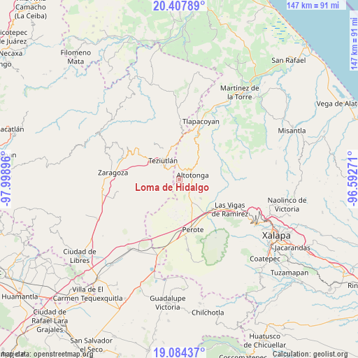
Loma de Hidalgo GPS coordinates[2]
19° 44' 51" North, 97° 17' 44.988" West
| Map corner | latitude | longitude |
|---|---|---|
| Upper-left | 20.40789°, | -97.99896° |
| Center: | 19.7475°, | -97.29583° |
| Lower-right: | 19.08437°, | -96.59271° |
| Map W x H: | 147.2×147.2 km | = 91.5×91.5mi |
| max Lat: | 32.7° ⇑48.5% North |
| Loma de Hidalgo: | 19.7475° |
| min Lat: | ⇓51.5% South 14.53588° |
| min Long | Loma de Hidalgo | max Long |
| -117.105° | -97.29583° | -86.73105° |
| W 71.6%⇐ | ⇒28.4% E |
Elevation
Elevation of Loma de Hidalgo is 2187 m = 7175 ft, and this is 933.3 m = 3062 ft above average elevation for this country.
| Max E: |
3497 m = 11473 ft | 18.1% |
| Loma de Hidalgo | 2187 m 7175 ft | |
| Avg. | 1253.7 m = 4113 ft | |
Min E: |
-1 m = -3 ft | 81.9% |
See also: Mexico elevation on elevation.city.
Geographical zone
Loma de Hidalgo is located in North Torrid zone (between Equator and Tropic of Cancer). Distance of this Northern Tropic circle is 410.2 km =254.9 mi to North.| Distance of | km | miles | from Loma de Hidalgo |
|---|---|---|---|
| North Pole | 7811.3 | 4853.7 | to North |
| Arctic Circle | 5205.5 | 3234.5 | to North |
| Tropic Cancer | 410.2 | 254.9 | to North |
| Equator | 2195.7 | 1364.3 | to South |


Nearby cities:
15 places around Loma de Hidalgo: (largest is in red/bold)
• Ahuacatán
4 km =2.5 mi,  357°
357°
• Ahueyahualco
4.9 km =3 mi,  129°
129°
• Altotonga
5.7 km =3.5 mi,  68°
68°
• Calpulalpan
3.7 km =2.3 mi,  153°
153°
• Champilico
3.8 km =2.4 mi,  100°
100°
• Cuauhtamingo
2.7 km =1.7 mi,  314°
314°
• El Zapote
5.2 km =3.2 mi, 307°
• Miguel Hidalgo
1.8 km =1.1 mi,  51°
51°
• Mixquiapan
5.5 km =3.4 mi,  160°
160°
• San Francisco
4.7 km =2.9 mi, 314°
• Texacaxco
4 km =2.5 mi,  61°
61°
• Tomaquilapa
2.9 km =1.8 mi,  290°
290°
• Veintiuno de Agosto
3.5 km =2.2 mi,  135°
135°
• Xaltipan (Sección Décima)
4.7 km =2.9 mi, 289°
• Zoatzingo
5.4 km =3.4 mi,  114°
114°
Sources, notices
• [Note1] Compared only with cities in Mexico existing in our database
• [Src1] Map data: © OpenStreetMap contributors (CC-BY-SA)
• [Src2] Other city data from geonames.org with taken over terms of usage.
• [Src3] Geographical zone / Annual Mean Temperature by Robert A. Rohde @ Wikipedia
