Agualeguas geodata
Agualeguas (Nuevo León) is a seat of a second-order administrative division; located in Mexico in America/Monterrey (GMT-6) time zone. With population of 1,995 people, there are 4360 cities with bigger population in this country. Compared to other cities in Mexico, 95.6% of cities are located further ↓South; 57.4% of cities are located further →East and 76% of cities have higher elevation than Agualeguas. Note1


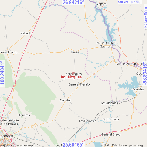
Agualeguas GPS coordinates[2]
26° 18' 49.032" North, 99° 32' 14.208" West
| Map corner | latitude | longitude |
|---|---|---|
| Upper-left | 26.94216°, | -100.24041° |
| Center: | 26.31362°, | -99.53728° |
| Lower-right: | 25.68165°, | -98.83416° |
| Map W x H: | 140.2×140.2 km | = 87.1×87.1mi |
| max Lat: | 32.7° ⇑4.4% North |
| Agualeguas: | 26.31362° |
| min Lat: | ⇓95.6% South 14.53588° |
| min Long | Agualeguas | max Long |
| -117.105° | -99.53728° | -86.73105° |
| W 42.6%⇐ | ⇒57.4% E |
Elevation
Elevation of Agualeguas is 185 m = 607 ft, and this is 1068.7 m = 3506 ft below average elevation for this country.
| Max E: |
3497 m = 11473 ft | 76% |
| Avg. | 1253.7 m = 4113 ft | |
| Agualeguas | 185 m = 607 ft | |
Min E: |
-1 m = -3 ft | 24% |
See also: Mexico elevation on elevation.city.
Geographical zone
Agualeguas is located in North temperate zone (between Tropic of Cancer and the Arctic Circle). Distance of this Northern Tropic circle is 319.9 km =198.8 mi to South.| Distance of | km | miles | from Agualeguas |
|---|---|---|---|
| North Pole | 7081.3 | 4400.1 | to North |
| Arctic Circle | 4475.4 | 2780.9 | to North |
| Tropic Cancer | 319.9 | 198.8 | to South |
| Equator | 2925.8 | 1818 | to South |


Nearby cities:
15 places around Agualeguas: (largest is in red/bold)
• Ciudad Cerralvo
26.6 km =16.5 mi,  196°
196°
• Ciudad Miguel Alemán
51.6 km =32.1 mi,  79°
79°
• Comales
63.2 km =39.3 mi,  103°
103°
• Doctor Coss
55.8 km =34.7 mi,  140°
140°
• General Treviño
11.3 km =7 mi,  152°
152°
• Higueras
61.8 km =38.4 mi,  230°
230°
• Los Aldamas
44.1 km =27.4 mi,  129°
129°
• Los Guerra
46.5 km =28.9 mi, 78°
• Los Herreras
47 km =29.2 mi,  163°
163°
• Los Ángeles
55.1 km =34.2 mi, 82°
• Melchor Ocampo
28.8 km =17.9 mi,  181°
181°
• Mier
40.5 km =25.2 mi,  71°
71°
• Nueva Ciudad Guerrero
41.3 km =25.7 mi,  48°
48°
• Parás
20.8 km =12.9 mi,  4°
4°
• Vallecillo
59.1 km =36.7 mi,  310°
310°
Sources, notices
• [Note1] Compared only with cities in Mexico existing in our database
• [Src1] Map data: © OpenStreetMap contributors (CC-BY-SA)
• [Src2] Other city data from geonames.org with taken over terms of usage.
• [Src3] Geographical zone / Annual Mean Temperature by Robert A. Rohde @ Wikipedia
