Ciudad Cerralvo geodata
Ciudad Cerralvo (Nuevo León) is a seat of a second-order administrative division; located in Mexico in America/Monterrey (GMT-6) time zone. With population of 7,169 people, there are 1293 cities with bigger population in this country. Compared to other cities in Mexico, 95.5% of cities are located further ↓South; 58.8% of cities are located further →East and 73% of cities have higher elevation than Ciudad Cerralvo. Note1


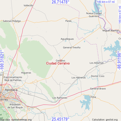
Ciudad Cerralvo GPS coordinates[2]
26° 5' 5.964" North, 99° 36' 54.288" West
| Map corner | latitude | longitude |
|---|---|---|
| Upper-left | 26.71478°, | -100.31821° |
| Center: | 26.08499°, | -99.61508° |
| Lower-right: | 25.45179°, | -98.91196° |
| Map W x H: | 140.4×140.4 km | = 87.2×87.2mi |
| max Lat: | 32.7° ⇑4.5% North |
| Ciudad Cerralvo: | 26.08499° |
| min Lat: | ⇓95.5% South 14.53588° |
| min Long | Ciudad Cerralvo | max Long |
| -117.105° | -99.61508° | -86.73105° |
| W 41.2%⇐ | ⇒58.8% E |
Elevation
Elevation of Ciudad Cerralvo is 289 m = 948 ft, and this is 964.7 m = 3165 ft below average elevation for this country.
| Max E: |
3497 m = 11473 ft | 73% |
| Avg. | 1253.7 m = 4113 ft | |
| Ciudad Cerralvo | 289 m = 948 ft | |
Min E: |
-1 m = -3 ft | 27% |
See also: Mexico elevation on elevation.city.
Geographical zone
Ciudad Cerralvo is located in North temperate zone (between Tropic of Cancer and the Arctic Circle). Distance of this Northern Tropic circle is 294.5 km =183 mi to South.| Distance of | km | miles | from Ciudad Cerralvo |
|---|---|---|---|
| North Pole | 7106.7 | 4415.9 | to North |
| Arctic Circle | 4500.8 | 2796.7 | to North |
| Tropic Cancer | 294.5 | 183 | to South |
| Equator | 2900.4 | 1802.2 | to South |


Nearby cities:
15 places around Ciudad Cerralvo: (largest is in red/bold)
• Agualeguas
26.6 km =16.5 mi,  16°
16°
• Doctor Coss
46.7 km =29 mi,  112°
112°
• Doctor González
41.3 km =25.7 mi,  232°
232°
• General Bravo
54.2 km =33.7 mi,  126°
126°
• General Treviño
20.1 km =12.5 mi,  40°
40°
• General Zuazua
53.6 km =33.3 mi,  246°
246°
• Higueras
42.3 km =26.3 mi, 250°
• Los Aldamas
42 km =26.1 mi,  93°
93°
• Los Herreras
28.8 km =17.9 mi, 133°
• Los Ramones
43.1 km =26.8 mi,  181°
181°
• Marín
47.4 km =29.5 mi,  241°
241°
• Melchor Ocampo
7.9 km =4.9 mi,  115°
115°
• Parás
47.1 km =29.3 mi,  11°
11°
• Portal de las Salinas
54 km =33.6 mi,  257°
257°
• San Isidro
47.9 km =29.8 mi,  197°
197°
Sources, notices
• [Note1] Compared only with cities in Mexico existing in our database
• [Src1] Map data: © OpenStreetMap contributors (CC-BY-SA)
• [Src2] Other city data from geonames.org with taken over terms of usage.
• [Src3] Geographical zone / Annual Mean Temperature by Robert A. Rohde @ Wikipedia
