General Treviño geodata
General Treviño (Nuevo León) is a seat of a second-order administrative division; located in Mexico in America/Monterrey (GMT-6) time zone. With population of 1,019 people, there are 8541 cities with bigger population in this country. Compared to other cities in Mexico, 95.6% of cities are located further ↓South; 56.8% of cities are located further →East and 76.8% of cities have higher elevation than General Treviño. Note1


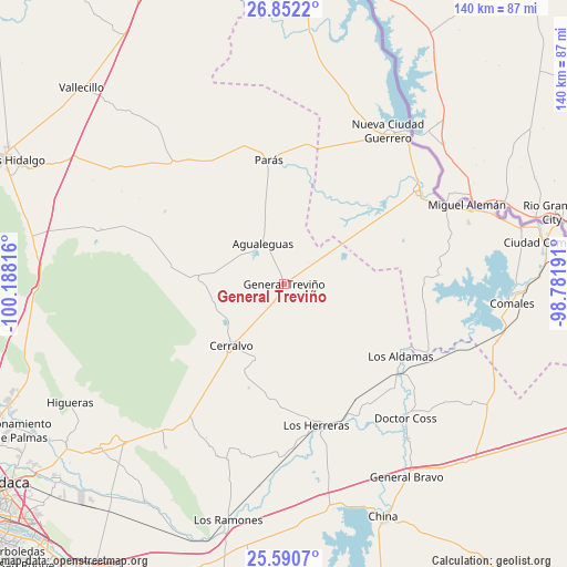
General Treviño GPS coordinates[2]
26° 13' 23.376" North, 99° 29' 6.108" West
| Map corner | latitude | longitude |
|---|---|---|
| Upper-left | 26.8522°, | -100.18816° |
| Center: | 26.22316°, | -99.48503° |
| Lower-right: | 25.5907°, | -98.78191° |
| Map W x H: | 140.3×140.3 km | = 87.2×87.2mi |
| max Lat: | 32.7° ⇑4.4% North |
| General Treviño: | 26.22316° |
| min Lat: | ⇓95.6% South 14.53588° |
| min Long | General Treviñ | max Long |
| -117.105° | -99.48503° | -86.73105° |
| W 43.2%⇐ | ⇒56.8% E |
Elevation
Elevation of General Treviño is 158 m = 518 ft, and this is 1095.7 m = 3595 ft below average elevation for this country.
| Max E: |
3497 m = 11473 ft | 76.8% |
| Avg. | 1253.7 m = 4113 ft | |
| General Treviño | 158 m = 518 ft | |
Min E: |
-1 m = -3 ft | 23.2% |
See also: Mexico elevation on elevation.city.
Geographical zone
General Treviño is located in North temperate zone (between Tropic of Cancer and the Arctic Circle). Distance of this Northern Tropic circle is 309.8 km =192.5 mi to South.| Distance of | km | miles | from General Treviño |
|---|---|---|---|
| North Pole | 7091.3 | 4406.3 | to North |
| Arctic Circle | 4485.4 | 2787.1 | to North |
| Tropic Cancer | 309.8 | 192.5 | to South |
| Equator | 2915.7 | 1811.7 | to South |


Nearby cities:
15 places around General Treviño: (largest is in red/bold)
• Agualeguas
11.3 km =7 mi,  332°
332°
• Ciudad Cerralvo
20.1 km =12.5 mi,  220°
220°
• Ciudad Miguel Alemán
49.6 km =30.8 mi,  66°
66°
• Comales
56.5 km =35.1 mi,  94°
94°
• Doctor Coss
44.8 km =27.8 mi,  137°
137°
• General Bravo
56.7 km =35.2 mi,  147°
147°
• Los Aldamas
34 km =21.1 mi,  121°
121°
• Los Guerra
44.7 km =27.8 mi,  64°
64°
• Los Herreras
36 km =22.4 mi,  167°
167°
• Los Ramones
60.1 km =37.3 mi,  193°
193°
• Los Ángeles
52.5 km =32.6 mi, 70°
• Melchor Ocampo
19.6 km =12.2 mi,  197°
197°
• Mier
40.3 km =25 mi, 55°
• Nueva Ciudad Guerrero
45.5 km =28.3 mi,  34°
34°
• Parás
31 km =19.3 mi,  353°
353°
Sources, notices
• [Note1] Compared only with cities in Mexico existing in our database
• [Src1] Map data: © OpenStreetMap contributors (CC-BY-SA)
• [Src2] Other city data from geonames.org with taken over terms of usage.
• [Src3] Geographical zone / Annual Mean Temperature by Robert A. Rohde @ Wikipedia
