Vallecillo geodata
Vallecillo (Nuevo León) is a seat of a second-order administrative division; located in Mexico in America/Monterrey (GMT-6) time zone. With population of 622 people, there are 13890 cities with bigger population in this country. Compared to other cities in Mexico, 95.9% of cities are located further ↓South; 63.8% of cities are located further →East and 73.6% of cities have higher elevation than Vallecillo. Note1


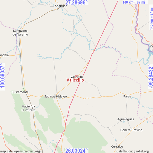
Vallecillo GPS coordinates[2]
26° 39' 37.188" North, 99° 59' 14.784" West
| Map corner | latitude | longitude |
|---|---|---|
| Upper-left | 27.28696°, | -100.69057° |
| Center: | 26.66033°, | -99.98744° |
| Lower-right: | 26.03024°, | -99.28432° |
| Map W x H: | 139.7×139.7 km | = 86.8×86.8mi |
| max Lat: | 32.7° ⇑4.1% North |
| Vallecillo: | 26.66033° |
| min Lat: | ⇓95.9% South 14.53588° |
| min Long | Vallecillo | max Long |
| -117.105° | -99.98744° | -86.73105° |
| W 36.2%⇐ | ⇒63.8% E |
Elevation
Elevation of Vallecillo is 268 m = 879 ft, and this is 985.7 m = 3234 ft below average elevation for this country.
| Max E: |
3497 m = 11473 ft | 73.6% |
| Avg. | 1253.7 m = 4113 ft | |
| Vallecillo | 268 m = 879 ft | |
Min E: |
-1 m = -3 ft | 26.4% |
See also: Mexico elevation on elevation.city.
Geographical zone
Vallecillo is located in North temperate zone (between Tropic of Cancer and the Arctic Circle). Distance of this Northern Tropic circle is 358.4 km =222.7 mi to South.| Distance of | km | miles | from Vallecillo |
|---|---|---|---|
| North Pole | 7042.7 | 4376.1 | to North |
| Arctic Circle | 4436.8 | 2756.9 | to North |
| Tropic Cancer | 358.4 | 222.7 | to South |
| Equator | 2964.4 | 1842 | to South |


Nearby cities:
15 places around Vallecillo: (largest is in red/bold)
• Agualeguas
59.1 km =36.7 mi,  130°
130°
• Anáhuac
66.5 km =41.3 mi,  347°
347°
• Bustamante
53.4 km =33.2 mi,  254°
254°
• Candela
70.3 km =43.7 mi,  286°
286°
• Ciudad Cerralvo
73.9 km =45.9 mi,  149°
149°
• Ciudad Sabinas Hidalgo
26 km =16.2 mi,  227°
227°
• Ciudad de Villaldama
47 km =29.2 mi, 247°
• El Potrero
52.6 km =32.7 mi,  236°
236°
• General Treviño
69.7 km =43.3 mi, 134°
• Lampazos de Naranjo
65.5 km =40.7 mi,  308°
308°
• Los Morales
75.9 km =47.2 mi,  206°
206°
• Los Villarreales
75.7 km =47 mi, 206°
• Mamulique
64.7 km =40.2 mi,  201°
201°
• Nueva Ciudad Guerrero
76.2 km =47.3 mi,  98°
98°
• Parás
49.6 km =30.8 mi,  111°
111°
Sources, notices
• [Note1] Compared only with cities in Mexico existing in our database
• [Src1] Map data: © OpenStreetMap contributors (CC-BY-SA)
• [Src2] Other city data from geonames.org with taken over terms of usage.
• [Src3] Geographical zone / Annual Mean Temperature by Robert A. Rohde @ Wikipedia
