Acatzingo geodata
Acatzingo (Puebla) is a seat of a second-order administrative division; located in Mexico in America/Mexico_City (GMT-6) time zone. With population of 25,811 people, there are 390 cities with bigger population in this country. Compared to other cities in Mexico, 65% of cities are located further ↑North; 66.3% of cities are located further ←West and 80.3% of cities have lower elevation than Acatzingo. Note1


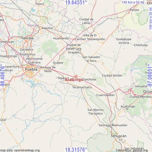
Acatzingo GPS coordinates[2]
18° 58' 55.056" North, 97° 47' 1.068" West
| Map corner | latitude | longitude |
|---|---|---|
| Upper-left | 19.64551°, | -98.48676° |
| Center: | 18.98196°, | -97.78363° |
| Lower-right: | 18.31576°, | -97.08051° |
| Map W x H: | 147.9×147.9 km | = 91.9×91.9mi |
| max Lat: | 32.7° ⇑65% North |
| Acatzingo: | 18.98196° |
| min Lat: | ⇓35% South 14.53588° |
| min Long | Acatzingo | max Long |
| -117.105° | -97.78363° | -86.73105° |
| W 66.3%⇐ | ⇒33.7% E |
Elevation
Elevation of Acatzingo is 2148 m = 7047 ft, and this is 894.3 m = 2934 ft above average elevation for this country.
| Max E: |
3497 m = 11473 ft | 19.7% |
| Acatzingo | 2148 m 7047 ft | |
| Avg. | 1253.7 m = 4113 ft | |
Min E: |
-1 m = -3 ft | 80.3% |
See also: Mexico elevation on elevation.city.
Geographical zone
Acatzingo is located in North Torrid zone (between Equator and Tropic of Cancer). Distance of this Northern Tropic circle is 495.3 km =307.8 mi to North.| Distance of | km | miles | from Acatzingo |
|---|---|---|---|
| North Pole | 7896.5 | 4906.7 | to North |
| Arctic Circle | 5290.6 | 3287.4 | to North |
| Tropic Cancer | 495.3 | 307.8 | to North |
| Equator | 2110.6 | 1311.5 | to South |


Nearby cities:
15 places around Acatzingo: (largest is in red/bold)
• Actipan de Morelos
2.9 km =1.8 mi,  213°
213°
• Buenavista de Juárez
6.2 km =3.9 mi,  228°
228°
• Carmen Serdán
6.7 km =4.2 mi,  333°
333°
• Guadalupe Morelos
5.3 km =3.3 mi,  335°
335°
• Huixcolotla
6.9 km =4.3 mi,  169°
169°
• La Compañia
6.5 km =4 mi,  100°
100°
• Los Reyes de Juárez
4.2 km =2.6 mi, 210°
• Miguel Negrete
5.8 km =3.6 mi,  235°
235°
• Nicolás Bravo
5.6 km =3.5 mi,  312°
312°
• Progreso de Juárez
3.7 km =2.3 mi,  127°
127°
• San Cristóbal Hidalgo
5.3 km =3.3 mi, 327°
• San Cristóbal los Nava
5.3 km =3.3 mi,  286°
286°
• San Francisco Buenavista
7.4 km =4.6 mi, 312°
• San Sebastián Teteles
5.7 km =3.5 mi,  352°
352°
• Santiago Acozac
4.1 km =2.5 mi, 226°
Sources, notices
• [Note1] Compared only with cities in Mexico existing in our database
• [Src1] Map data: © OpenStreetMap contributors (CC-BY-SA)
• [Src2] Other city data from geonames.org with taken over terms of usage.
• [Src3] Geographical zone / Annual Mean Temperature by Robert A. Rohde @ Wikipedia
