Guadalupe Morelos geodata
Guadalupe Morelos (Puebla) is a populated place; located in Mexico in America/Mexico_City (GMT-6) time zone. With population of 1,058 people, there are 8247 cities with bigger population in this country. Compared to other cities in Mexico, 64.2% of cities are located further ↑North; 66% of cities are located further ←West and 83.3% of cities have lower elevation than Guadalupe Morelos. Note1


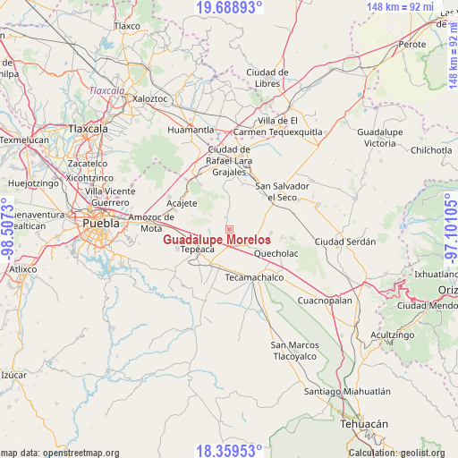
Guadalupe Morelos GPS coordinates[2]
19° 1' 32.016" North, 97° 48' 15.012" West
| Map corner | latitude | longitude |
|---|---|---|
| Upper-left | 19.68893°, | -98.5073° |
| Center: | 19.02556°, | -97.80417° |
| Lower-right: | 18.35953°, | -97.10105° |
| Map W x H: | 147.8×147.8 km | = 91.8×91.8mi |
| max Lat: | 32.7° ⇑64.2% North |
| Guadalupe Morelos: | 19.02556° |
| min Lat: | ⇓35.8% South 14.53588° |
| min Long | Guadalupe Morel | max Long |
| -117.105° | -97.80417° | -86.73105° |
| W 66%⇐ | ⇒34% E |
Elevation
Elevation of Guadalupe Morelos is 2225 m = 7300 ft, and this is 971.3 m = 3187 ft above average elevation for this country.
| Max E: |
3497 m = 11473 ft | 16.7% |
| Guadalupe Morelos | 2225 m 7300 ft | |
| Avg. | 1253.7 m = 4113 ft | |
Min E: |
-1 m = -3 ft | 83.3% |
See also: Mexico elevation on elevation.city.
Geographical zone
Guadalupe Morelos is located in North Torrid zone (between Equator and Tropic of Cancer). Distance of this Northern Tropic circle is 490.5 km =304.8 mi to North.| Distance of | km | miles | from Guadalupe Morelos |
|---|---|---|---|
| North Pole | 7891.6 | 4903.6 | to North |
| Arctic Circle | 5285.7 | 3284.4 | to North |
| Tropic Cancer | 490.5 | 304.8 | to North |
| Equator | 2115.4 | 1314.4 | to South |


Nearby cities:
15 places around Guadalupe Morelos: (largest is in red/bold)
• Acatzingo
5.3 km =3.3 mi,  155°
155°
• Actipan de Morelos
7.3 km =4.5 mi,  175°
175°
• Benito Juárez
5.9 km =3.7 mi,  251°
251°
• Carmen Serdán
1.5 km =0.9 mi,  325°
325°
• Los Reyes de Ocampo
4.6 km =2.9 mi,  307°
307°
• Nicolás Bravo
2.2 km =1.4 mi,  242°
242°
• San Cristóbal Hidalgo
0.8 km =0.5 mi, 237°
• San Cristóbal los Nava
4.5 km =2.8 mi,  220°
220°
• San Francisco Buenavista
3.3 km =2.1 mi,  271°
271°
• San Lorenzo Joya de Rodríguez
6.1 km =3.8 mi,  301°
301°
• San Mateo Parra
7.1 km =4.4 mi, 237°
• San Miguel
7.2 km =4.5 mi, 311°
• San Pedro la Joya
5.7 km =3.5 mi,  321°
321°
• San Sebastián Teteles
1.7 km =1.1 mi,  62°
62°
• Vincente Guerrero
3.9 km =2.4 mi,  339°
339°
Sources, notices
• [Note1] Compared only with cities in Mexico existing in our database
• [Src1] Map data: © OpenStreetMap contributors (CC-BY-SA)
• [Src2] Other city data from geonames.org with taken over terms of usage.
• [Src3] Geographical zone / Annual Mean Temperature by Robert A. Rohde @ Wikipedia
