San Nicolás Tecomatlán geodata
San Nicolás Tecomatlán (Hidalgo) is a populated place; located in Mexico in America/Mexico_City (GMT-6) time zone. With population of 2,375 people, there are 3719 cities with bigger population in this country. Compared to other cities in Mexico, 60.9% of cities are located further ↓South; 50.3% of cities are located further →East and 82% of cities have lower elevation than San Nicolás Tecomatlán. Note1
Current local time in San Nicolás Tecomatlán:
05:36 AM, WednesdayDifference from your time zone: hours


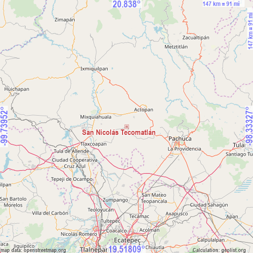
San Nicolás Tecomatlán GPS coordinates[2]
20° 10' 45.984" North, 99° 2' 11.004" West
| Map corner | latitude | longitude |
|---|---|---|
| Upper-left | 20.838°, | -99.73952° |
| Center: | 20.17944°, | -99.03639° |
| Lower-right: | 19.51809°, | -98.33327° |
| Map W x H: | 146.8×146.8 km | = 91.2×91.2mi |
| max Lat: | 32.7° ⇑39.1% North |
| San Nicolás Tecomatlán: | 20.17944° |
| min Lat: | ⇓60.9% South 14.53588° |
| min Long | San Nicolás Te | max Long |
| -117.105° | -99.03639° | -86.73105° |
| W 49.7%⇐ | ⇒50.3% E |
Elevation
Elevation of San Nicolás Tecomatlán is 2189 m = 7182 ft, and this is 935.3 m = 3069 ft above average elevation for this country.
| Max E: |
3497 m = 11473 ft | 18% |
| San Nicolás Tecomatlán | 2189 m 7182 ft | |
| Avg. | 1253.7 m = 4113 ft | |
Min E: |
-1 m = -3 ft | 82% |
See also: Mexico elevation on elevation.city.
Geographical zone
San Nicolás Tecomatlán is located in North Torrid zone (between Equator and Tropic of Cancer). Distance of this Northern Tropic circle is 362.2 km =225.1 mi to North.| Distance of | km | miles | from San Nicolás Tecomatlán |
|---|---|---|---|
| North Pole | 7763.3 | 4823.9 | to North |
| Arctic Circle | 5157.4 | 3204.7 | to North |
| Tropic Cancer | 362.2 | 225.1 | to North |
| Equator | 2243.7 | 1394.2 | to South |


Nearby cities:
15 places around San Nicolás Tecomatlán: (largest is in red/bold)
• Arambó
8 km =5 mi,  324°
324°
• Bocamiño
7.8 km =4.8 mi,  332°
332°
• Casa Blanca
8.6 km =5.3 mi,  34°
34°
• El Colorado
5.3 km =3.3 mi,  41°
41°
• El Puerto Lázaro Cárdenas
4.9 km =3 mi,  19°
19°
• El Rosario
7.8 km =4.8 mi,  8°
8°
• El Tablón
5.8 km =3.6 mi,  56°
56°
• Ignacio Zaragoza
6.7 km =4.2 mi,  145°
145°
• La Cruz
8.6 km =5.3 mi,  302°
302°
• Los Filtros
7 km =4.3 mi,  308°
308°
• Lázaro Cárdenas
7.9 km =4.9 mi, 309°
• San Juan Tepa
5.1 km =3.2 mi, 322°
• Santa María Amajac
6.8 km =4.2 mi, 35°
• Santiago Tezontlale
6.8 km =4.2 mi,  253°
253°
• Vicente Guerrero
2.7 km =1.7 mi,  235°
235°
Sources, notices
• [Note1] Compared only with cities in Mexico existing in our database
• [Src1] Map data: © OpenStreetMap contributors (CC-BY-SA)
• [Src2] Other city data from geonames.org with taken over terms of usage.
• [Src3] Geographical zone / Annual Mean Temperature by Robert A. Rohde @ Wikipedia
