Los Filtros geodata
Los Filtros (Hidalgo) is a populated place; located in Mexico in America/Mexico_City (GMT-6) time zone. With population of 716 people, there are 12166 cities with bigger population in this country. Compared to other cities in Mexico, 61.8% of cities are located further ↓South; 51% of cities are located further →East and 75.2% of cities have lower elevation than Los Filtros. Note1


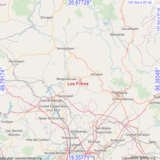
Los Filtros GPS coordinates[2]
20° 13' 8.004" North, 99° 5' 18.996" West
| Map corner | latitude | longitude |
|---|---|---|
| Upper-left | 20.87728°, | -99.79174° |
| Center: | 20.21889°, | -99.08861° |
| Lower-right: | 19.55771°, | -98.38549° |
| Map W x H: | 146.7×146.7 km | = 91.2×91.2mi |
| max Lat: | 32.7° ⇑38.2% North |
| Los Filtros: | 20.21889° |
| min Lat: | ⇓61.8% South 14.53588° |
| min Long | Los Filtros | max Long |
| -117.105° | -99.08861° | -86.73105° |
| W 49%⇐ | ⇒51% E |
Elevation
Elevation of Los Filtros is 2034 m = 6673 ft, and this is 780.3 m = 2560 ft above average elevation for this country.
| Max E: |
3497 m = 11473 ft | 24.8% |
| Los Filtros | 2034 m 6673 ft | |
| Avg. | 1253.7 m = 4113 ft | |
Min E: |
-1 m = -3 ft | 75.2% |
See also: Mexico elevation on elevation.city.
Geographical zone
Los Filtros is located in North Torrid zone (between Equator and Tropic of Cancer). Distance of this Northern Tropic circle is 357.8 km =222.3 mi to North.| Distance of | km | miles | from Los Filtros |
|---|---|---|---|
| North Pole | 7758.9 | 4821.2 | to North |
| Arctic Circle | 5153 | 3201.9 | to North |
| Tropic Cancer | 357.8 | 222.3 | to North |
| Equator | 2248.1 | 1396.9 | to South |


Nearby cities:
15 places around Los Filtros: (largest is in red/bold)
• Arambó
2.3 km =1.4 mi,  20°
20°
• Bocamiño
3.1 km =1.9 mi,  35°
35°
• Colonia Morelos (El Nueve)
5.5 km =3.4 mi,  277°
277°
• Dengantzha
6.8 km =4.2 mi,  330°
330°
• La Comunidad
3.5 km =2.2 mi, 21°
• La Cruz
1.8 km =1.1 mi, 276°
• La Puerta
4.8 km =3 mi,  322°
322°
• Lázaro Cárdenas
0.9 km =0.6 mi,  314°
314°
• Pacheco
6.3 km =3.9 mi, 37°
• San José Boxay
5 km =3.1 mi,  345°
345°
• San Juan Tepa
2.4 km =1.5 mi,  98°
98°
• San Nicolás Tecomatlán
7 km =4.3 mi,  128°
128°
• Santiago Tezontlale
6.4 km =4 mi,  189°
189°
• Tepatepec
3 km =1.9 mi,  357°
357°
• Vicente Guerrero
6.8 km =4.2 mi,  151°
151°
Sources, notices
• [Note1] Compared only with cities in Mexico existing in our database
• [Src1] Map data: © OpenStreetMap contributors (CC-BY-SA)
• [Src2] Other city data from geonames.org with taken over terms of usage.
• [Src3] Geographical zone / Annual Mean Temperature by Robert A. Rohde @ Wikipedia
