Bocamiño geodata
Bocamiño (Hidalgo) is a populated place; located in Mexico in America/Mexico_City (GMT-6) time zone. With population of 981 people, there are 8862 cities with bigger population in this country. Compared to other cities in Mexico, 62.3% of cities are located further ↓South; 50.7% of cities are located further →East and 72.5% of cities have lower elevation than Bocamiño. Note1


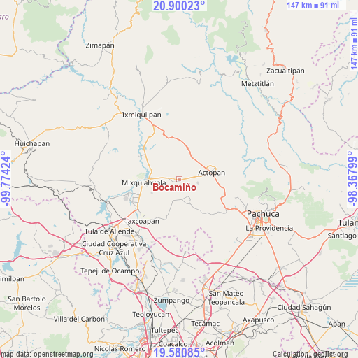
Bocamiño GPS coordinates[2]
20° 14' 30.984" North, 99° 4' 15.996" West
| Map corner | latitude | longitude |
|---|---|---|
| Upper-left | 20.90023°, | -99.77424° |
| Center: | 20.24194°, | -99.07111° |
| Lower-right: | 19.58085°, | -98.36799° |
| Map W x H: | 146.7×146.7 km | = 91.2×91.2mi |
| max Lat: | 32.7° ⇑37.7% North |
| Bocamiño: | 20.24194° |
| min Lat: | ⇓62.3% South 14.53588° |
| min Long | Bocamiño | max Long |
| -117.105° | -99.07111° | -86.73105° |
| W 49.3%⇐ | ⇒50.7% E |
Elevation
Elevation of Bocamiño is 1978 m = 6490 ft, and this is 724.3 m = 2376 ft above average elevation for this country.
| Max E: |
3497 m = 11473 ft | 27.5% |
| Bocamiño | 1978 m 6490 ft | |
| Avg. | 1253.7 m = 4113 ft | |
Min E: |
-1 m = -3 ft | 72.5% |
See also: Mexico elevation on elevation.city.
Geographical zone
Bocamiño is located in North Torrid zone (between Equator and Tropic of Cancer). Distance of this Northern Tropic circle is 355.2 km =220.7 mi to North.| Distance of | km | miles | from Bocamiño |
|---|---|---|---|
| North Pole | 7756.4 | 4819.6 | to North |
| Arctic Circle | 5150.5 | 3200.4 | to North |
| Tropic Cancer | 355.2 | 220.7 | to North |
| Equator | 2250.7 | 1398.5 | to South |


Nearby cities:
15 places around Bocamiño: (largest is in red/bold)
• Arambó
1.1 km =0.7 mi,  246°
246°
• El Olvera
5.7 km =3.5 mi,  56°
56°
• El Puerto Lázaro Cárdenas
5.8 km =3.6 mi,  114°
114°
• El Rosario
4.8 km =3 mi,  81°
81°
• La Comunidad
0.9 km =0.6 mi,  322°
322°
• La Cruz
4.3 km =2.7 mi,  237°
237°
• La Puerta
4.9 km =3 mi,  284°
284°
• Los Filtros
3.1 km =1.9 mi,  215°
215°
• Lázaro Cárdenas
3.1 km =1.9 mi,  232°
232°
• Pacheco
3.1 km =1.9 mi,  39°
39°
• San José Boxay
3.8 km =2.4 mi,  306°
306°
• San Juan Tepa
3 km =1.9 mi,  169°
169°
• San Miguel Acambay
4.2 km =2.6 mi,  23°
23°
• Tepatepec
2 km =1.2 mi, 282°
• Vixtha de Madero
4.8 km =3 mi, 43°
Sources, notices
• [Note1] Compared only with cities in Mexico existing in our database
• [Src1] Map data: © OpenStreetMap contributors (CC-BY-SA)
• [Src2] Other city data from geonames.org with taken over terms of usage.
• [Src3] Geographical zone / Annual Mean Temperature by Robert A. Rohde @ Wikipedia
