Tuxtepec geodata
Tuxtepec (Oaxaca) is a populated place; located in Mexico in America/Mexico_City (GMT-6) time zone. With population of 101,810 people, there are 133 cities with bigger population in this country. Compared to other cities in Mexico, 77.7% of cities are located further ↑North; 81.7% of cities are located further ←West and 87.7% of cities have higher elevation than Tuxtepec. Note1


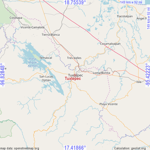
Tuxtepec GPS coordinates[2]
18° 5' 17.88" North, 96° 7' 31.26" West
| Map corner | latitude | longitude |
|---|---|---|
| Upper-left | 18.75539°, | -96.82848° |
| Center: | 18.0883°, | -96.12535° |
| Lower-right: | 17.41866°, | -95.42223° |
| Map W x H: | 148.6×148.6 km | = 92.3×92.3mi |
| max Lat: | 32.7° ⇑77.7% North |
| Tuxtepec: | 18.0883° |
| min Lat: | ⇓22.3% South 14.53588° |
| min Long | Tuxtepec | max Long |
| -117.105° | -96.12535° | -86.73105° |
| W 81.7%⇐ | ⇒18.3% E |
Elevation
Elevation of Tuxtepec is 31 m = 102 ft, and this is 1222.7 m = 4011 ft below average elevation for this country.
| Max E: |
3497 m = 11473 ft | 87.7% |
| Avg. | 1253.7 m = 4113 ft | |
| Tuxtepec | 31 m = 102 ft | |
Min E: |
-1 m = -3 ft | 12.3% |
See also: Tuxtepec elevation on elevation.city.
Geographical zone
Tuxtepec is located in North Torrid zone (between Equator and Tropic of Cancer). Distance of this Northern Tropic circle is 594.7 km =369.5 mi to North.| Distance of | km | miles | from Tuxtepec |
|---|---|---|---|
| North Pole | 7995.8 | 4968.4 | to North |
| Arctic Circle | 5389.9 | 3349.1 | to North |
| Tropic Cancer | 594.7 | 369.5 | to North |
| Equator | 2011.2 | 1249.7 | to South |


Nearby cities:
15 places around Tuxtepec: (largest is in red/bold)
• Camelia Roja
11 km =6.8 mi,  232°
232°
• El Camarón
8.5 km =5.3 mi,  286°
286°
• El Cedral
9.5 km =5.9 mi,  145°
145°
• El Porvenir
12.2 km =7.6 mi,  307°
307°
• Fortino J. Pinacho
12.1 km =7.5 mi,  205°
205°
• Gabino Barreda
10.7 km =6.6 mi,  19°
19°
• La Mina
11.6 km =7.2 mi,  166°
166°
• Las Peñitas
5.9 km =3.7 mi,  345°
345°
• Mata de Caña
6.3 km =3.9 mi, 171°
• Papaloapan
8.7 km =5.4 mi, 22°
• San Bartolo
1.9 km =1.2 mi,  76°
76°
• San Isidro
9.7 km =6 mi,  315°
315°
• Santa Cruz
9.6 km =6 mi, 19°
• Sebastopol
7.9 km =4.9 mi,  219°
219°
• Soledad Macín Chico
10.5 km =6.5 mi,  252°
252°
Sources, notices
• [Note1] Compared only with cities in Mexico existing in our database
• [Src1] Map data: © OpenStreetMap contributors (CC-BY-SA)
• [Src2] Other city data from geonames.org with taken over terms of usage.
• [Src3] Geographical zone / Annual Mean Temperature by Robert A. Rohde @ Wikipedia
