Quelové geodata
Quelové (Oaxaca) is a populated place; located in Mexico in America/Mexico_City (GMT-6) time zone. With population of 1,037 people, there are 8413 cities with bigger population in this country. Compared to other cities in Mexico, 97.3% of cities are located further ↑North; 78.6% of cities are located further ←West and 53% of cities have higher elevation than Quelové. Note1


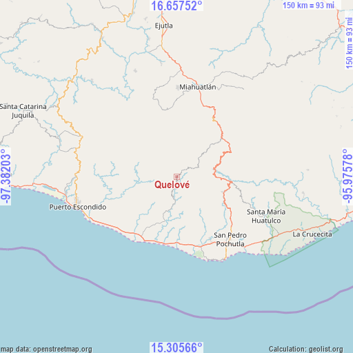
Quelové GPS coordinates[2]
15° 58' 57.828" North, 96° 40' 44.04" West
| Map corner | latitude | longitude |
|---|---|---|
| Upper-left | 16.65752°, | -97.38203° |
| Center: | 15.98273°, | -96.6789° |
| Lower-right: | 15.30566°, | -95.97578° |
| Map W x H: | 150.3×150.3 km | = 93.4×93.4mi |
| max Lat: | 32.7° ⇑97.3% North |
| Quelové: | 15.98273° |
| min Lat: | ⇓2.7% South 14.53588° |
| min Long | Quelové | max Long |
| -117.105° | -96.6789° | -86.73105° |
| W 78.6%⇐ | ⇒21.4% E |
Elevation
Elevation of Quelové is 1290 m = 4232 ft, and this is 36.3 m = 119 ft above average elevation for this country.
| Max E: |
3497 m = 11473 ft | 53% |
| Quelové | 1290 m 4232 ft | |
| Avg. | 1253.7 m = 4113 ft | |
Min E: |
-1 m = -3 ft | 47% |
See also: Mexico elevation on elevation.city.
Geographical zone
Quelové is located in North Torrid zone (between Equator and Tropic of Cancer). Distance of this Northern Tropic circle is 828.8 km =515 mi to North.| Distance of | km | miles | from Quelové |
|---|---|---|---|
| North Pole | 8229.9 | 5113.8 | to North |
| Arctic Circle | 5624.1 | 3494.7 | to North |
| Tropic Cancer | 828.8 | 515 | to North |
| Equator | 1777.1 | 1104.2 | to South |


Nearby cities:
15 places around Quelové: (largest is in red/bold)
• Buenavista Loxicha
13.9 km =8.6 mi,  105°
105°
• Cerro Cantor
7.3 km =4.5 mi,  136°
136°
• El Camalote
13.6 km =8.5 mi,  154°
154°
• La Sirena
3.1 km =1.9 mi, 114°
• Magdalena Loxícha
9.1 km =5.7 mi,  188°
188°
• Piedra Virgen
4.2 km =2.6 mi,  155°
155°
• Piedra del Sol
13.3 km =8.3 mi, 157°
• San Agustín Loxicha
7.7 km =4.8 mi,  60°
60°
• San Baltazar Loxicha
15.6 km =9.7 mi,  312°
312°
• San Bartolomé Loxícha
3.6 km =2.2 mi,  246°
246°
• San Francisco Loxicha
11 km =6.8 mi, 140°
• San Vicente Yogodoy
11.7 km =7.3 mi,  34°
34°
• Santa Catarina Loxicha
12.5 km =7.8 mi,  319°
319°
• Santa Cruz Loxícha
2.2 km =1.4 mi,  354°
354°
• Santo Domingo de Morelos
16.6 km =10.3 mi,  175°
175°
Sources, notices
• [Note1] Compared only with cities in Mexico existing in our database
• [Src1] Map data: © OpenStreetMap contributors (CC-BY-SA)
• [Src2] Other city data from geonames.org with taken over terms of usage.
• [Src3] Geographical zone / Annual Mean Temperature by Robert A. Rohde @ Wikipedia
