El Vigía geodata
El Vigía (Oaxaca) is a populated place; located in Mexico in America/Mexico_City (GMT-6) time zone. With population of 703 people, there are 12379 cities with bigger population in this country. Compared to other cities in Mexico, 98.1% of cities are located further ↑North; 79.9% of cities are located further ←West and 76.2% of cities have higher elevation than El Vigía. Note1


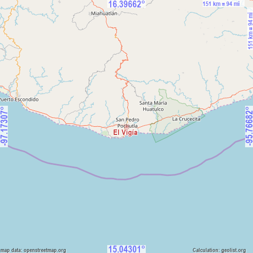
El Vigía GPS coordinates[2]
15° 43' 15.384" North, 96° 28' 11.784" West
| Map corner | latitude | longitude |
|---|---|---|
| Upper-left | 16.39662°, | -97.17307° |
| Center: | 15.72094°, | -96.46994° |
| Lower-right: | 15.04301°, | -95.76682° |
| Map W x H: | 150.5×150.5 km | = 93.5×93.5mi |
| max Lat: | 32.7° ⇑98.1% North |
| El Vigía: | 15.72094° |
| min Lat: | ⇓1.9% South 14.53588° |
| min Long | El Vigía | max Long |
| -117.105° | -96.46994° | -86.73105° |
| W 79.9%⇐ | ⇒20.1% E |
Elevation
Elevation of El Vigía is 179 m = 587 ft, and this is 1074.7 m = 3526 ft below average elevation for this country.
| Max E: |
3497 m = 11473 ft | 76.2% |
| Avg. | 1253.7 m = 4113 ft | |
| El Vigía | 179 m = 587 ft | |
Min E: |
-1 m = -3 ft | 23.8% |
See also: Mexico elevation on elevation.city.
Geographical zone
El Vigía is located in North Torrid zone (between Equator and Tropic of Cancer). Distance of this Northern Tropic circle is 857.9 km =533.1 mi to North.| Distance of | km | miles | from El Vigía |
|---|---|---|---|
| North Pole | 8259.1 | 5132 | to North |
| Arctic Circle | 5653.2 | 3512.7 | to North |
| Tropic Cancer | 857.9 | 533.1 | to North |
| Equator | 1748 | 1086.2 | to South |


Nearby cities:
15 places around El Vigía: (largest is in red/bold)
• Cuatode
5.4 km =3.4 mi,  283°
283°
• El Colorado
1.1 km =0.7 mi,  237°
237°
• El Mazunte
10.9 km =6.8 mi, 236°
• Laguna Seca (Sección Cuarta)
1.9 km =1.2 mi,  20°
20°
• Puerto Ángel
6.2 km =3.9 mi,  201°
201°
• Reyes
10.8 km =6.7 mi,  349°
349°
• San Antonio
12 km =7.5 mi,  267°
267°
• San Isidro Apango
15.5 km =9.6 mi,  50°
50°
• San Isidro del Palmar
15 km =9.3 mi, 269°
• San José Chacalapa
12.1 km =7.5 mi,  3°
3°
• San Miguel Figueroa
10.1 km =6.3 mi,  44°
44°
• San Pedro Pochutla
2.8 km =1.7 mi,  8°
8°
• San Roque
7.4 km =4.6 mi, 5°
• Santa María Limón
14.1 km =8.8 mi, 50°
• Santa María Tonameca
8.8 km =5.5 mi,  290°
290°
Sources, notices
• [Note1] Compared only with cities in Mexico existing in our database
• [Src1] Map data: © OpenStreetMap contributors (CC-BY-SA)
• [Src2] Other city data from geonames.org with taken over terms of usage.
• [Src3] Geographical zone / Annual Mean Temperature by Robert A. Rohde @ Wikipedia
