Reyes geodata
Reyes (Oaxaca) is a populated place; located in Mexico in America/Mexico_City (GMT-6) time zone. With population of 692 people, there are 12576 cities with bigger population in this country. Compared to other cities in Mexico, 97.8% of cities are located further ↑North; 79.8% of cities are located further ←West and 75.1% of cities have higher elevation than Reyes. Note1


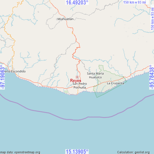
Reyes GPS coordinates[2]
15° 49' 0.012" North, 96° 29' 15" West
| Map corner | latitude | longitude |
|---|---|---|
| Upper-left | 16.49203°, | -97.19063° |
| Center: | 15.81667°, | -96.4875° |
| Lower-right: | 15.13905°, | -95.78438° |
| Map W x H: | 150.4×150.4 km | = 93.5×93.5mi |
| max Lat: | 32.7° ⇑97.8% North |
| Reyes: | 15.81667° |
| min Lat: | ⇓2.2% South 14.53588° |
| min Long | Reyes | max Long |
| -117.105° | -96.4875° | -86.73105° |
| W 79.8%⇐ | ⇒20.2% E |
Elevation
Elevation of Reyes is 219 m = 719 ft, and this is 1034.7 m = 3395 ft below average elevation for this country.
| Max E: |
3497 m = 11473 ft | 75.1% |
| Avg. | 1253.7 m = 4113 ft | |
| Reyes | 219 m = 719 ft | |
Min E: |
-1 m = -3 ft | 24.9% |
See also: Mexico elevation on elevation.city.
Geographical zone
Reyes is located in North Torrid zone (between Equator and Tropic of Cancer). Distance of this Northern Tropic circle is 847.3 km =526.5 mi to North.| Distance of | km | miles | from Reyes |
|---|---|---|---|
| North Pole | 8248.4 | 5125.3 | to North |
| Arctic Circle | 5642.5 | 3506.1 | to North |
| Tropic Cancer | 847.3 | 526.5 | to North |
| Equator | 1758.6 | 1092.7 | to South |


Nearby cities:
15 places around Reyes: (largest is in red/bold)
• Candelaria Loxicha
12.2 km =7.6 mi,  357°
357°
• Cuatode
9.9 km =6.2 mi,  200°
200°
• El Colorado
11.3 km =7 mi,  175°
175°
• El Vigía
10.8 km =6.7 mi,  169°
169°
• Laguna Seca (Sección Cuarta)
9.2 km =5.7 mi,  164°
164°
• Las Cuevas
12.7 km =7.9 mi,  264°
264°
• Los Horcones
9.8 km =6.1 mi,  282°
282°
• San José Chacalapa
2.9 km =1.8 mi,  60°
60°
• San José Piedras Negras
11.3 km =7 mi, 281°
• San Miguel Figueroa
9.5 km =5.9 mi,  110°
110°
• San Pedro Pochutla
8.2 km =5.1 mi, 163°
• San Roque
4.2 km =2.6 mi,  142°
142°
• Santa María Tepejipana
11.2 km =7 mi,  337°
337°
• Santa María Tonameca
9.9 km =6.2 mi,  219°
219°
• Toltepec
8.2 km =5.1 mi,  25°
25°
Sources, notices
• [Note1] Compared only with cities in Mexico existing in our database
• [Src1] Map data: © OpenStreetMap contributors (CC-BY-SA)
• [Src2] Other city data from geonames.org with taken over terms of usage.
• [Src3] Geographical zone / Annual Mean Temperature by Robert A. Rohde @ Wikipedia
