San Pedro Pochutla geodata
San Pedro Pochutla (Oaxaca) is a seat of a second-order administrative division; located in Mexico in America/Mexico_City (GMT-6) time zone. With population of 13,685 people, there are 710 cities with bigger population in this country. Compared to other cities in Mexico, 98% of cities are located further ↑North; 79.9% of cities are located further ←West and 76.9% of cities have higher elevation than San Pedro Pochutla. Note1


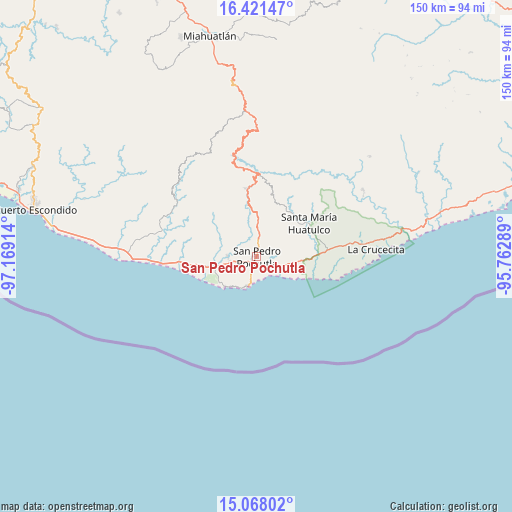
San Pedro Pochutla GPS coordinates[2]
15° 44' 45.132" North, 96° 27' 57.636" West
| Map corner | latitude | longitude |
|---|---|---|
| Upper-left | 16.42147°, | -97.16914° |
| Center: | 15.74587°, | -96.46601° |
| Lower-right: | 15.06802°, | -95.76289° |
| Map W x H: | 150.5×150.5 km | = 93.5×93.5mi |
| max Lat: | 32.7° ⇑98% North |
| San Pedro Pochutla: | 15.74587° |
| min Lat: | ⇓2% South 14.53588° |
| min Long | San Pedro Pochu | max Long |
| -117.105° | -96.46601° | -86.73105° |
| W 79.9%⇐ | ⇒20.1% E |
Elevation
Elevation of San Pedro Pochutla is 156 m = 512 ft, and this is 1097.7 m = 3601 ft below average elevation for this country.
| Max E: |
3497 m = 11473 ft | 76.9% |
| Avg. | 1253.7 m = 4113 ft | |
| San Pedro Pochutla | 156 m = 512 ft | |
Min E: |
-1 m = -3 ft | 23.1% |
See also: Mexico elevation on elevation.city.
Geographical zone
San Pedro Pochutla is located in North Torrid zone (between Equator and Tropic of Cancer). Distance of this Northern Tropic circle is 855.1 km =531.3 mi to North.| Distance of | km | miles | from San Pedro Pochutla |
|---|---|---|---|
| North Pole | 8256.3 | 5130.2 | to North |
| Arctic Circle | 5650.4 | 3511 | to North |
| Tropic Cancer | 855.1 | 531.3 | to North |
| Equator | 1750.8 | 1087.9 | to South |


Nearby cities:
15 places around San Pedro Pochutla: (largest is in red/bold)
• Cuatode
5.9 km =3.7 mi,  255°
255°
• El Colorado
3.6 km =2.2 mi,  201°
201°
• El Mazunte
12.9 km =8 mi,  227°
227°
• El Vigía
2.8 km =1.7 mi,  188°
188°
• Laguna Seca (Sección Cuarta)
1 km =0.6 mi,  167°
167°
• Puerto Ángel
9 km =5.6 mi, 197°
• Reyes
8.2 km =5.1 mi,  343°
343°
• San Antonio
12.8 km =8 mi,  254°
254°
• San Isidro Apango
13.5 km =8.4 mi,  58°
58°
• San José Chacalapa
9.3 km =5.8 mi,  1°
1°
• San Miguel Figueroa
8 km =5 mi, 55°
• San Roque
4.6 km =2.9 mi, 3°
• Santa María Limón
12.1 km =7.5 mi, 58°
• Santa María Tonameca
8.7 km =5.4 mi,  271°
271°
• Toltepec
15.3 km =9.5 mi, 4°
Sources, notices
• [Note1] Compared only with cities in Mexico existing in our database
• [Src1] Map data: © OpenStreetMap contributors (CC-BY-SA)
• [Src2] Other city data from geonames.org with taken over terms of usage.
• [Src3] Geographical zone / Annual Mean Temperature by Robert A. Rohde @ Wikipedia
