San Miguel Figueroa geodata
San Miguel Figueroa (Oaxaca) is a populated place; located in Mexico in America/Mexico_City (GMT-6) time zone. With population of 1,137 people, there are 7633 cities with bigger population in this country. Compared to other cities in Mexico, 97.9% of cities are located further ↑North; 80.2% of cities are located further ←West and 75.5% of cities have higher elevation than San Miguel Figueroa. Note1


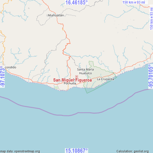
San Miguel Figueroa GPS coordinates[2]
15° 47' 11.004" North, 96° 24' 15.012" West
| Map corner | latitude | longitude |
|---|---|---|
| Upper-left | 16.46185°, | -97.1073° |
| Center: | 15.78639°, | -96.40417° |
| Lower-right: | 15.10867°, | -95.70105° |
| Map W x H: | 150.5×150.5 km | = 93.5×93.5mi |
| max Lat: | 32.7° ⇑97.9% North |
| San Miguel Figueroa: | 15.78639° |
| min Lat: | ⇓2.1% South 14.53588° |
| min Long | San Miguel Figu | max Long |
| -117.105° | -96.40417° | -86.73105° |
| W 80.2%⇐ | ⇒19.8% E |
Elevation
Elevation of San Miguel Figueroa is 205 m = 673 ft, and this is 1048.7 m = 3441 ft below average elevation for this country.
| Max E: |
3497 m = 11473 ft | 75.5% |
| Avg. | 1253.7 m = 4113 ft | |
| San Miguel Figueroa | 205 m = 673 ft | |
Min E: |
-1 m = -3 ft | 24.5% |
See also: Mexico elevation on elevation.city.
Geographical zone
San Miguel Figueroa is located in North Torrid zone (between Equator and Tropic of Cancer). Distance of this Northern Tropic circle is 850.6 km =528.5 mi to North.| Distance of | km | miles | from San Miguel Figueroa |
|---|---|---|---|
| North Pole | 8251.8 | 5127.4 | to North |
| Arctic Circle | 5645.9 | 3508.2 | to North |
| Tropic Cancer | 850.6 | 528.5 | to North |
| Equator | 1755.3 | 1090.7 | to South |


Nearby cities:
15 places around San Miguel Figueroa: (largest is in red/bold)
• Benito Juárez
13.6 km =8.5 mi,  38°
38°
• Cuapinolito (Azulillo)
10 km =6.2 mi,  66°
66°
• El Colorado
11.2 km =7 mi,  225°
225°
• El Vigía
10.1 km =6.3 mi,  224°
224°
• La Erradura
9.1 km =5.7 mi,  54°
54°
• Laguna Seca (Sección Cuarta)
8.4 km =5.2 mi, 229°
• Paso Ancho
11.4 km =7.1 mi,  56°
56°
• Reyes
9.5 km =5.9 mi,  290°
290°
• San Isidro Apango
5.5 km =3.4 mi, 62°
• San José Chacalapa
8 km =5 mi,  306°
306°
• San Pedro Pochutla
8 km =5 mi,  235°
235°
• San Roque
6.3 km =3.9 mi,  270°
270°
• Santa María Huatulco
10.3 km =6.4 mi, 60°
• Santa María Limón
4.1 km =2.5 mi, 65°
• Toltepec
12 km =7.5 mi,  333°
333°
Sources, notices
• [Note1] Compared only with cities in Mexico existing in our database
• [Src1] Map data: © OpenStreetMap contributors (CC-BY-SA)
• [Src2] Other city data from geonames.org with taken over terms of usage.
• [Src3] Geographical zone / Annual Mean Temperature by Robert A. Rohde @ Wikipedia
