Teotongo geodata
Teotongo (Oaxaca) is a populated place; located in Mexico in America/Mexico_City (GMT-6) time zone. With population of 519 people, there are 16226 cities with bigger population in this country. Compared to other cities in Mexico, 81.1% of cities are located further ↑North; 69.2% of cities are located further ←West and 77.2% of cities have lower elevation than Teotongo. Note1


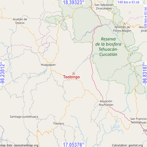
Teotongo GPS coordinates[2]
17° 43' 29.1" North, 97° 32' 5.964" West
| Map corner | latitude | longitude |
|---|---|---|
| Upper-left | 18.39323°, | -98.23812° |
| Center: | 17.72475°, | -97.53499° |
| Lower-right: | 17.05376°, | -96.83187° |
| Map W x H: | 148.9×148.9 km | = 92.5×92.5mi |
| max Lat: | 32.7° ⇑81.1% North |
| Teotongo: | 17.72475° |
| min Lat: | ⇓18.9% South 14.53588° |
| min Long | Teotongo | max Long |
| -117.105° | -97.53499° | -86.73105° |
| W 69.2%⇐ | ⇒30.8% E |
Elevation
Elevation of Teotongo is 2073 m = 6801 ft, and this is 819.3 m = 2688 ft above average elevation for this country.
| Max E: |
3497 m = 11473 ft | 22.8% |
| Teotongo | 2073 m 6801 ft | |
| Avg. | 1253.7 m = 4113 ft | |
Min E: |
-1 m = -3 ft | 77.2% |
See also: Mexico elevation on elevation.city.
Geographical zone
Teotongo is located in North Torrid zone (between Equator and Tropic of Cancer). Distance of this Northern Tropic circle is 635.1 km =394.6 mi to North.| Distance of | km | miles | from Teotongo |
|---|---|---|---|
| North Pole | 8036.3 | 4993.5 | to North |
| Arctic Circle | 5430.4 | 3374.3 | to North |
| Tropic Cancer | 635.1 | 394.6 | to North |
| Equator | 1970.8 | 1224.6 | to South |


Nearby cities:
15 places around Teotongo: (largest is in red/bold)
• Coixtlahuaca
22.9 km =14.2 mi,  91°
91°
• Corral de Piedra
21.5 km =13.4 mi,  278°
278°
• El Molino
23.7 km =14.7 mi, 283°
• La Junta
25.1 km =15.6 mi,  297°
297°
• Nativitas
22.3 km =13.9 mi,  108°
108°
• San Andrés Dinicuiti
20.7 km =12.9 mi,  258°
258°
• San Antonio de León
21.4 km =13.3 mi, 261°
• San Pedro y San Pablo Teposcolula
24.3 km =15.1 mi,  168°
168°
• San Sebastián Progreso
19.2 km =11.9 mi, 300°
• Santiago Cacaloxtepec
21.8 km =13.5 mi,  269°
269°
• Santiago Huajolotitlán
23.9 km =14.9 mi, 298°
• Santo Domingo Yodohino
19.7 km =12.2 mi,  232°
232°
• Tamazulapam Villa del Progreso
6.7 km =4.2 mi,  217°
217°
• Villa Tejúpam de la Unión
9.7 km =6 mi,  135°
135°
• Vista Hermosa
24.8 km =15.4 mi,  288°
288°
Sources, notices
• [Note1] Compared only with cities in Mexico existing in our database
• [Src1] Map data: © OpenStreetMap contributors (CC-BY-SA)
• [Src2] Other city data from geonames.org with taken over terms of usage.
• [Src3] Geographical zone / Annual Mean Temperature by Robert A. Rohde @ Wikipedia
