Chila geodata
Chila (Puebla) is a seat of a second-order administrative division; located in Mexico in America/Mexico_City (GMT-6) time zone. With population of 1,954 people, there are 4460 cities with bigger population in this country. Compared to other cities in Mexico, 79% of cities are located further ↑North; 65.3% of cities are located further ←West and 56.4% of cities have lower elevation than Chila. Note1


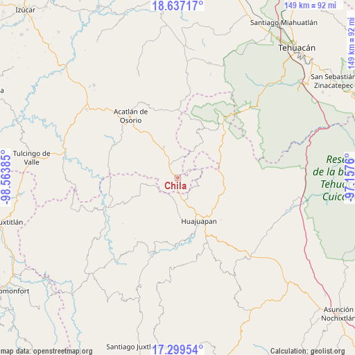
Chila GPS coordinates[2]
17° 58' 10.632" North, 97° 51' 38.592" West
| Map corner | latitude | longitude |
|---|---|---|
| Upper-left | 18.63717°, | -98.56385° |
| Center: | 17.96962°, | -97.86072° |
| Lower-right: | 17.29954°, | -97.1576° |
| Map W x H: | 148.7×148.7 km | = 92.4×92.4mi |
| max Lat: | 32.7° ⇑79% North |
| Chila: | 17.96962° |
| min Lat: | ⇓21% South 14.53588° |
| min Long | Chila | max Long |
| -117.105° | -97.86072° | -86.73105° |
| W 65.3%⇐ | ⇒34.7% E |
Elevation
Elevation of Chila is 1634 m = 5361 ft, and this is 380.3 m = 1248 ft above average elevation for this country.
| Max E: |
3497 m = 11473 ft | 43.6% |
| Chila | 1634 m 5361 ft | |
| Avg. | 1253.7 m = 4113 ft | |
Min E: |
-1 m = -3 ft | 56.4% |
See also: Mexico elevation on elevation.city.
Geographical zone
Chila is located in North Torrid zone (between Equator and Tropic of Cancer). Distance of this Northern Tropic circle is 607.9 km =377.7 mi to North.| Distance of | km | miles | from Chila |
|---|---|---|---|
| North Pole | 8009 | 4976.6 | to North |
| Arctic Circle | 5403.1 | 3357.3 | to North |
| Tropic Cancer | 607.9 | 377.7 | to North |
| Equator | 1998 | 1241.5 | to South |


Nearby cities:
15 places around Chila: (largest is in red/bold)
• Acatilma
16.7 km =10.4 mi,  161°
161°
• Colonia Buena Vista
16.8 km =10.4 mi, 163°
• Francisco Ibarra Ramos
6.1 km =3.8 mi,  278°
278°
• Petlalcingo
14.1 km =8.8 mi,  334°
334°
• San Jerónimo Silacayoapilla
17.8 km =11.1 mi,  174°
174°
• San Jorge el Zapote
15.8 km =9.8 mi,  246°
246°
• San José Ayuquila
11.8 km =7.3 mi,  255°
255°
• San Miguel Ixitlán
9.7 km =6 mi,  69°
69°
• Santa Catarina Estancia
16.1 km =10 mi, 264°
• Santa Gertrudis Salitrillo
6.8 km =4.2 mi,  323°
323°
• Santiago Ayuquililla
11 km =6.8 mi, 248°
• Santiago Chilixtlahuaca
8 km =5 mi,  207°
207°
• Tepejillo
9.4 km =5.8 mi,  13°
13°
• Texcalapa de Juárez
17.2 km =10.7 mi,  308°
308°
• Zapotitlán Palmas
10 km =6.2 mi,  153°
153°
Sources, notices
• [Note1] Compared only with cities in Mexico existing in our database
• [Src1] Map data: © OpenStreetMap contributors (CC-BY-SA)
• [Src2] Other city data from geonames.org with taken over terms of usage.
• [Src3] Geographical zone / Annual Mean Temperature by Robert A. Rohde @ Wikipedia
