San Jorge el Zapote geodata
San Jorge el Zapote (Oaxaca) is a populated place; located in Mexico in America/Mexico_City (GMT-6) time zone. With population of 653 people, there are 13279 cities with bigger population in this country. Compared to other cities in Mexico, 79.6% of cities are located further ↑North; 63.6% of cities are located further ←West and 50.7% of cities have lower elevation than San Jorge el Zapote. Note1


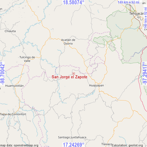
San Jorge el Zapote GPS coordinates[2]
17° 54' 46.728" North, 97° 59' 50.244" West
| Map corner | latitude | longitude |
|---|---|---|
| Upper-left | 18.58074°, | -98.70042° |
| Center: | 17.91298°, | -97.99729° |
| Lower-right: | 17.24269°, | -97.29417° |
| Map W x H: | 148.8×148.8 km | = 92.5×92.5mi |
| max Lat: | 32.7° ⇑79.6% North |
| San Jorge el Zapote: | 17.91298° |
| min Lat: | ⇓20.4% South 14.53588° |
| min Long | San Jorge el Za | max Long |
| -117.105° | -97.99729° | -86.73105° |
| W 63.6%⇐ | ⇒36.4% E |
Elevation
Elevation of San Jorge el Zapote is 1472 m = 4829 ft, and this is 218.3 m = 716 ft above average elevation for this country.
| Max E: |
3497 m = 11473 ft | 49.3% |
| San Jorge el Zapote | 1472 m 4829 ft | |
| Avg. | 1253.7 m = 4113 ft | |
Min E: |
-1 m = -3 ft | 50.7% |
See also: Mexico elevation on elevation.city.
Geographical zone
San Jorge el Zapote is located in North Torrid zone (between Equator and Tropic of Cancer). Distance of this Northern Tropic circle is 614.2 km =381.6 mi to North.| Distance of | km | miles | from San Jorge el Zapote |
|---|---|---|---|
| North Pole | 8015.3 | 4980.5 | to North |
| Arctic Circle | 5409.4 | 3361.2 | to North |
| Tropic Cancer | 614.2 | 381.6 | to North |
| Equator | 1991.7 | 1237.6 | to South |


Nearby cities:
15 places around San Jorge el Zapote: (largest is in red/bold)
• 5 de Mayo
9.1 km =5.7 mi,  183°
183°
• Chila
15.8 km =9.8 mi,  66°
66°
• Francisco Ibarra Ramos
11.1 km =6.9 mi,  49°
49°
• Mariscala de Juárez
16.3 km =10.1 mi,  248°
248°
• San José Ayuquila
4.4 km =2.7 mi,  43°
43°
• San Lorenzo Vista Hermosa
9.1 km =5.7 mi,  304°
304°
• San Martín Zacatepec
13.5 km =8.4 mi,  209°
209°
• San Miguel Amatitlán
3.7 km =2.3 mi,  230°
230°
• Santa Catarina Estancia
5.1 km =3.2 mi,  342°
342°
• Santa Gertrudis Salitrillo
15.8 km =9.8 mi, 41°
• Santiago Ayuquililla
4.7 km =2.9 mi,  61°
61°
• Santiago Chilixtlahuaca
10.8 km =6.7 mi,  94°
94°
• Santo Domingo Yolotepec
12.1 km =7.5 mi,  158°
158°
• Santos Reyes Yucuna
15.2 km =9.4 mi, 181°
• Texcalapa de Juárez
16.9 km =10.5 mi,  3°
3°
Sources, notices
• [Note1] Compared only with cities in Mexico existing in our database
• [Src1] Map data: © OpenStreetMap contributors (CC-BY-SA)
• [Src2] Other city data from geonames.org with taken over terms of usage.
• [Src3] Geographical zone / Annual Mean Temperature by Robert A. Rohde @ Wikipedia
