Carbonera geodata
Carbonera (Oaxaca) is a populated place; located in Mexico in America/Mexico_City (GMT-6) time zone. With population of 770 people, there are 11354 cities with bigger population in this country. Compared to other cities in Mexico, 73.2% of cities are located further ↑North; 80.1% of cities are located further ←West and 80.5% of cities have higher elevation than Carbonera. Note1


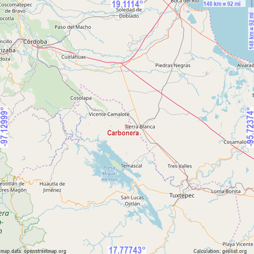
Carbonera GPS coordinates[2]
18° 26' 44.556" North, 96° 25' 36.696" West
| Map corner | latitude | longitude |
|---|---|---|
| Upper-left | 19.1114°, | -97.12999° |
| Center: | 18.44571°, | -96.42686° |
| Lower-right: | 17.77743°, | -95.72374° |
| Map W x H: | 148.3×148.3 km | = 92.1×92.1mi |
| max Lat: | 32.7° ⇑73.2% North |
| Carbonera: | 18.44571° |
| min Lat: | ⇓26.8% South 14.53588° |
| min Long | Carbonera | max Long |
| -117.105° | -96.42686° | -86.73105° |
| W 80.1%⇐ | ⇒19.9% E |
Elevation
Elevation of Carbonera is 87 m = 285 ft, and this is 1166.7 m = 3828 ft below average elevation for this country.
| Max E: |
3497 m = 11473 ft | 80.5% |
| Avg. | 1253.7 m = 4113 ft | |
| Carbonera | 87 m = 285 ft | |
Min E: |
-1 m = -3 ft | 19.5% |
See also: Mexico elevation on elevation.city.
Geographical zone
Carbonera is located in North Torrid zone (between Equator and Tropic of Cancer). Distance of this Northern Tropic circle is 554.9 km =344.8 mi to North.| Distance of | km | miles | from Carbonera |
|---|---|---|---|
| North Pole | 7956.1 | 4943.7 | to North |
| Arctic Circle | 5350.2 | 3324.5 | to North |
| Tropic Cancer | 554.9 | 344.8 | to North |
| Equator | 2051 | 1274.4 | to South |


Nearby cities:
15 places around Carbonera: (largest is in red/bold)
• Arroyo de Pita
9 km =5.6 mi,  130°
130°
• El Amate
11.6 km =7.2 mi,  23°
23°
• El Cedral
10.4 km =6.5 mi,  212°
212°
• El Porvenir
8.8 km =5.5 mi,  321°
321°
• Joliette
6.3 km =3.9 mi,  123°
123°
• La Palma
2.6 km =1.6 mi,  344°
344°
• La Raya
7.8 km =4.8 mi, 125°
• La Tabaquera
12.5 km =7.8 mi,  191°
191°
• La Victoria
11 km =6.8 mi,  82°
82°
• Nuevo Pescadito de Málzaga (La Breña)
11.4 km =7.1 mi,  155°
155°
• Palma Sola
10 km =6.2 mi,  108°
108°
• Tembladera de la Selva 1
9.6 km =6 mi,  273°
273°
• Tembladera del Castillo
9.6 km =6 mi,  232°
232°
• Tetela
7.8 km =4.8 mi,  334°
334°
• Tierra Blanca
7.1 km =4.4 mi,  88°
88°
Sources, notices
• [Note1] Compared only with cities in Mexico existing in our database
• [Src1] Map data: © OpenStreetMap contributors (CC-BY-SA)
• [Src2] Other city data from geonames.org with taken over terms of usage.
• [Src3] Geographical zone / Annual Mean Temperature by Robert A. Rohde @ Wikipedia
