Palma Sola geodata
Palma Sola (Veracruz) is a populated place; located in Mexico in America/Mexico_City (GMT-6) time zone. With population of 587 people, there are 14622 cities with bigger population in this country. Compared to other cities in Mexico, 73.5% of cities are located further ↑North; 80.7% of cities are located further ←West and 82.5% of cities have higher elevation than Palma Sola. Note1


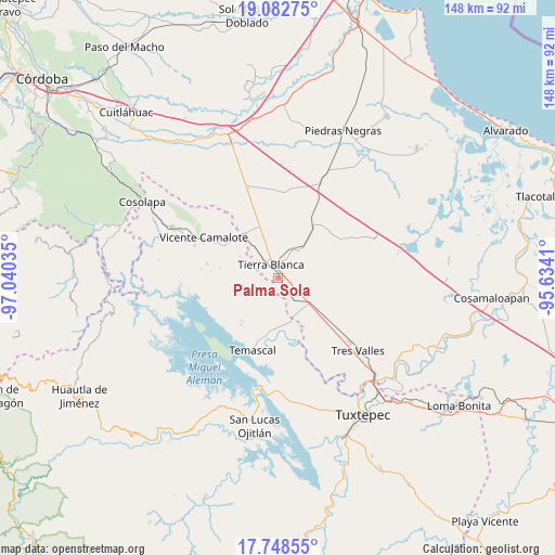
Palma Sola GPS coordinates[2]
18° 25' 0.984" North, 96° 20' 13.992" West
| Map corner | latitude | longitude |
|---|---|---|
| Upper-left | 19.08275°, | -97.04035° |
| Center: | 18.41694°, | -96.33722° |
| Lower-right: | 17.74855°, | -95.6341° |
| Map W x H: | 148.3×148.4 km | = 92.1×92.2mi |
| max Lat: | 32.7° ⇑73.5% North |
| Palma Sola: | 18.41694° |
| min Lat: | ⇓26.5% South 14.53588° |
| min Long | Palma Sola | max Long |
| -117.105° | -96.33722° | -86.73105° |
| W 80.7%⇐ | ⇒19.3% E |
Elevation
Elevation of Palma Sola is 65 m = 213 ft, and this is 1188.7 m = 3900 ft below average elevation for this country.
| Max E: |
3497 m = 11473 ft | 82.5% |
| Avg. | 1253.7 m = 4113 ft | |
| Palma Sola | 65 m = 213 ft | |
Min E: |
-1 m = -3 ft | 17.5% |
See also: Mexico elevation on elevation.city.
Geographical zone
Palma Sola is located in North Torrid zone (between Equator and Tropic of Cancer). Distance of this Northern Tropic circle is 558.1 km =346.8 mi to North.| Distance of | km | miles | from Palma Sola |
|---|---|---|---|
| North Pole | 7959.3 | 4945.7 | to North |
| Arctic Circle | 5353.4 | 3326.4 | to North |
| Tropic Cancer | 558.1 | 346.8 | to North |
| Equator | 2047.8 | 1272.4 | to South |


Nearby cities:
15 places around Palma Sola: (largest is in red/bold)
• Arroyo de Pita
3.7 km =2.3 mi,  224°
224°
• Carbonera
10 km =6.2 mi,  288°
288°
• El Amate
14.6 km =9.1 mi,  340°
340°
• Joliette
4.2 km =2.6 mi,  265°
265°
• La Atalaya
3.9 km =2.4 mi,  118°
118°
• La Granja
10.7 km =6.6 mi,  129°
129°
• La Palma
11.6 km =7.2 mi,  299°
299°
• La Raya
3.4 km =2.1 mi,  245°
245°
• La Reforma
12.8 km =8 mi,  169°
169°
• La Reforma
12.9 km =8 mi,  178°
178°
• La Victoria
4.8 km =3 mi,  17°
17°
• Nuevo Paso Nazareno (Chichicazapa)
13.4 km =8.3 mi, 184°
• Nuevo Pescadito de Málzaga (La Breña)
8.5 km =5.3 mi,  213°
213°
• Rancho Grande
7.1 km =4.4 mi,  190°
190°
• Tierra Blanca
4.1 km =2.5 mi,  325°
325°
Sources, notices
• [Note1] Compared only with cities in Mexico existing in our database
• [Src1] Map data: © OpenStreetMap contributors (CC-BY-SA)
• [Src2] Other city data from geonames.org with taken over terms of usage.
• [Src3] Geographical zone / Annual Mean Temperature by Robert A. Rohde @ Wikipedia
