Morelos geodata
Morelos (Tabasco) is a populated place; located in Mexico in America/Mexico_City (GMT-6) time zone. With population of 655 people, there are 13244 cities with bigger population in this country. Compared to other cities in Mexico, 79.5% of cities are located further ↑North; 91.2% of cities are located further ←West and 97.5% of cities have higher elevation than Morelos. Note1


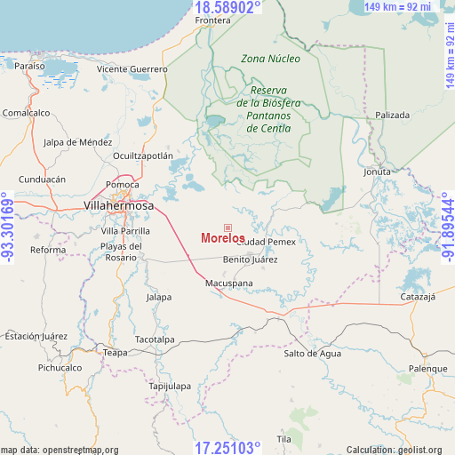
Morelos GPS coordinates[2]
17° 55' 16.644" North, 92° 35' 54.816" West
| Map corner | latitude | longitude |
|---|---|---|
| Upper-left | 18.58902°, | -93.30169° |
| Center: | 17.92129°, | -92.59856° |
| Lower-right: | 17.25103°, | -91.89544° |
| Map W x H: | 148.8×148.8 km | = 92.5×92.5mi |
| max Lat: | 32.7° ⇑79.5% North |
| Morelos: | 17.92129° |
| min Lat: | ⇓20.5% South 14.53588° |
| min Long | Morelos | max Long |
| -117.105° | -92.59856° | -86.73105° |
| W 91.2%⇐ | ⇒8.8% E |
Elevation
Elevation of Morelos is 9 m = 30 ft, and this is 1244.7 m = 4084 ft below average elevation for this country.
| Max E: |
3497 m = 11473 ft | 97.5% |
| Avg. | 1253.7 m = 4113 ft | |
| Morelos | 9 m = 30 ft | |
Min E: |
-1 m = -3 ft | 2.5% |
See also: Mexico elevation on elevation.city.
Geographical zone
Morelos is located in North Torrid zone (between Equator and Tropic of Cancer). Distance of this Northern Tropic circle is 613.3 km =381.1 mi to North.| Distance of | km | miles | from Morelos |
|---|---|---|---|
| North Pole | 8014.4 | 4979.9 | to North |
| Arctic Circle | 5408.5 | 3360.7 | to North |
| Tropic Cancer | 613.3 | 381.1 | to North |
| Equator | 1992.7 | 1238.2 | to South |


Nearby cities:
15 places around Morelos: (largest is in red/bold)
• Benito González
12.9 km =8 mi,  243°
243°
• Buenavista
6.9 km =4.3 mi,  94°
94°
• Buergos
12.6 km =7.8 mi,  201°
201°
• Cacahuatalillo
14 km =8.7 mi,  148°
148°
• Ciudad Pemex
12.9 km =8 mi,  109°
109°
• Emiliano Zapata 2da. Sección
7.7 km =4.8 mi,  176°
176°
• La Curva
13.2 km =8.2 mi,  117°
117°
• La Escalera
11.6 km =7.2 mi,  138°
138°
• La Unión
13.5 km =8.4 mi,  126°
126°
• Limón 1ra. Sección Sector B
11.4 km =7.1 mi, 107°
• Miraflores 3ra. Sección
13.5 km =8.4 mi,  272°
272°
• Monte Largo 1ra. Sección
9.6 km =6 mi,  185°
185°
• Nueva Esperanza
7.9 km =4.9 mi, 132°
• San Carlos
12.2 km =7.6 mi, 143°
• Veinte de Noviembre
8.3 km =5.2 mi,  173°
173°
Sources, notices
• [Note1] Compared only with cities in Mexico existing in our database
• [Src1] Map data: © OpenStreetMap contributors (CC-BY-SA)
• [Src2] Other city data from geonames.org with taken over terms of usage.
• [Src3] Geographical zone / Annual Mean Temperature by Robert A. Rohde @ Wikipedia
