Benito Juárez geodata
Benito Juárez (Tabasco) is a populated place; located in Mexico in America/Mexico_City (GMT-6) time zone. With population of 615 people, there are 14017 cities with bigger population in this country. Compared to other cities in Mexico, 81.6% of cities are located further ↑North; 86.2% of cities are located further ←West and 87.2% of cities have higher elevation than Benito Juárez. Note1


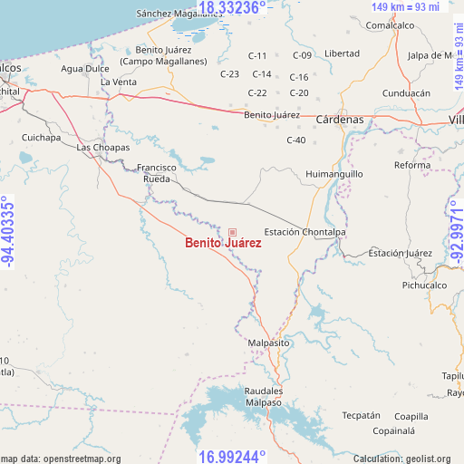
Benito Juárez GPS coordinates[2]
17° 39' 49.14" North, 93° 42' 0.792" West
| Map corner | latitude | longitude |
|---|---|---|
| Upper-left | 18.33236°, | -94.40335° |
| Center: | 17.66365°, | -93.70022° |
| Lower-right: | 16.99244°, | -92.9971° |
| Map W x H: | 149×149 km | = 92.6×92.6mi |
| max Lat: | 32.7° ⇑81.6% North |
| Benito Juárez: | 17.66365° |
| min Lat: | ⇓18.4% South 14.53588° |
| min Long | Benito Juárez | max Long |
| -117.105° | -93.70022° | -86.73105° |
| W 86.2%⇐ | ⇒13.8% E |
Elevation
Elevation of Benito Juárez is 33 m = 108 ft, and this is 1220.7 m = 4005 ft below average elevation for this country.
| Max E: |
3497 m = 11473 ft | 87.2% |
| Avg. | 1253.7 m = 4113 ft | |
| Benito Juárez | 33 m = 108 ft | |
Min E: |
-1 m = -3 ft | 12.8% |
See also: Mexico elevation on elevation.city.
Geographical zone
Benito Juárez is located in North Torrid zone (between Equator and Tropic of Cancer). Distance of this Northern Tropic circle is 641.9 km =398.9 mi to North.| Distance of | km | miles | from Benito Juárez |
|---|---|---|---|
| North Pole | 8043 | 4997.7 | to North |
| Arctic Circle | 5437.2 | 3378.5 | to North |
| Tropic Cancer | 641.9 | 398.9 | to North |
| Equator | 1964 | 1220.4 | to South |


Nearby cities:
15 places around Benito Juárez: (largest is in red/bold)
• Chicoacán
25.7 km =16 mi,  64°
64°
• Chicoacán (Ampliación)
28.2 km =17.5 mi,  68°
68°
• Chontalpa
23.2 km =14.4 mi,  89°
89°
• Economía
11.4 km =7.1 mi,  109°
109°
• Francisco J. Santamaría 1ra. Sección
20.2 km =12.6 mi, 109°
• Francisco Martínez Gaytán
16.7 km =10.4 mi,  314°
314°
• Gilberto Flores Muñoz
19.1 km =11.9 mi,  83°
83°
• Graciano Sánchez
27.6 km =17.1 mi,  230°
230°
• Huapacal 2da. Sección
27.4 km =17 mi,  343°
343°
• Ignacio López Rayón
24.7 km =15.3 mi,  222°
222°
• José María Morelos y Pavón
21.4 km =13.3 mi,  118°
118°
• José María Pino Suárez 1ra. Sección
10.7 km =6.6 mi,  29°
29°
• Manuel Sánchez Mármol
10.6 km =6.6 mi,  345°
345°
• Pedregal Moctezuma 2da. Sección (Leyva)
8.4 km =5.2 mi, 112°
• Tierra Colorada 1ra. Sección
25.3 km =15.7 mi,  3°
3°
Sources, notices
• [Note1] Compared only with cities in Mexico existing in our database
• [Src1] Map data: © OpenStreetMap contributors (CC-BY-SA)
• [Src2] Other city data from geonames.org with taken over terms of usage.
• [Src3] Geographical zone / Annual Mean Temperature by Robert A. Rohde @ Wikipedia
