Palomas geodata
Palomas (Tabasco) is a populated place; located in Mexico in America/Mexico_City (GMT-6) time zone. With population of 1,544 people, there are 5587 cities with bigger population in this country. Compared to other cities in Mexico, 81.7% of cities are located further ↑North; 92% of cities are located further ←West and 88% of cities have higher elevation than Palomas. Note1


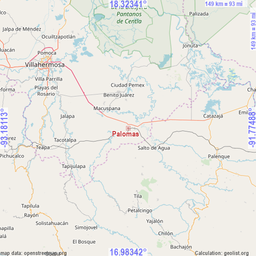
Palomas GPS coordinates[2]
17° 39' 16.776" North, 92° 28' 40.8" West
| Map corner | latitude | longitude |
|---|---|---|
| Upper-left | 18.32341°, | -93.18113° |
| Center: | 17.65466°, | -92.478° |
| Lower-right: | 16.98342°, | -91.77488° |
| Map W x H: | 149×149 km | = 92.6×92.6mi |
| max Lat: | 32.7° ⇑81.7% North |
| Palomas: | 17.65466° |
| min Lat: | ⇓18.3% South 14.53588° |
| min Long | Palomas | max Long |
| -117.105° | -92.478° | -86.73105° |
| W 92%⇐ | ⇒8% E |
Elevation
Elevation of Palomas is 30 m = 98 ft, and this is 1223.7 m = 4015 ft below average elevation for this country.
| Max E: |
3497 m = 11473 ft | 88% |
| Avg. | 1253.7 m = 4113 ft | |
| Palomas | 30 m = 98 ft | |
Min E: |
-1 m = -3 ft | 12% |
See also: Mexico elevation on elevation.city.
Geographical zone
Palomas is located in North Torrid zone (between Equator and Tropic of Cancer). Distance of this Northern Tropic circle is 642.9 km =399.5 mi to North.| Distance of | km | miles | from Palomas |
|---|---|---|---|
| North Pole | 8044 | 4998.3 | to North |
| Arctic Circle | 5438.2 | 3379.1 | to North |
| Tropic Cancer | 642.9 | 399.5 | to North |
| Equator | 1963 | 1219.8 | to South |


Nearby cities:
15 places around Palomas: (largest is in red/bold)
• Aquiles Serdán (San Fernando)
16.8 km =10.4 mi,  355°
355°
• Buena Vista (Apasco)
3.6 km =2.2 mi,  88°
88°
• Buena Vista (Puxcatán)
17.3 km =10.7 mi,  299°
299°
• Cerro Misopa
12 km =7.5 mi,  201°
201°
• Francisco Javier Mina (El Coco)
4.4 km =2.7 mi,  53°
53°
• Francisco Villa
8.3 km =5.2 mi,  273°
273°
• Ignacio Zaragoza (Los Ateos)
17.9 km =11.1 mi,  320°
320°
• La Ceiba
14.4 km =8.9 mi,  10°
10°
• Los Luceros 2da. Sección
15.1 km =9.4 mi,  157°
157°
• Macuspana
17.1 km =10.6 mi,  313°
313°
• Nicolás Bravo
16.3 km =10.1 mi,  294°
294°
• Paso Chinal
18 km =11.2 mi,  191°
191°
• Profesor Caparroso 1ra. Sección
4.2 km =2.6 mi,  212°
212°
• Usipa
17.7 km =11 mi,  166°
166°
• Zopo Norte
6 km =3.7 mi,  104°
104°
Sources, notices
• [Note1] Compared only with cities in Mexico existing in our database
• [Src1] Map data: © OpenStreetMap contributors (CC-BY-SA)
• [Src2] Other city data from geonames.org with taken over terms of usage.
• [Src3] Geographical zone / Annual Mean Temperature by Robert A. Rohde @ Wikipedia
