La Estación geodata
La Estación (Hidalgo) is a populated place; located in Mexico in America/Mexico_City (GMT-6) time zone. With population of 620 people, there are 13925 cities with bigger population in this country. Compared to other cities in Mexico, 67.7% of cities are located further ↓South; 52.1% of cities are located further →East and 63.3% of cities have lower elevation than La Estación. Note1


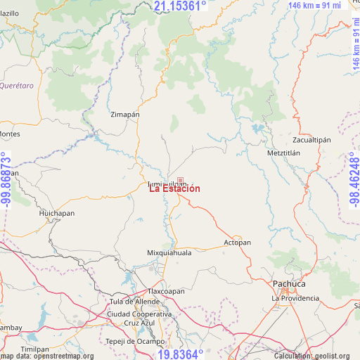
La Estación GPS coordinates[2]
20° 29' 47.112" North, 99° 9' 56.16" West
| Map corner | latitude | longitude |
|---|---|---|
| Upper-left | 21.15361°, | -99.86873° |
| Center: | 20.49642°, | -99.1656° |
| Lower-right: | 19.8364°, | -98.46248° |
| Map W x H: | 146.5×146.5 km | = 91×91mi |
| max Lat: | 32.7° ⇑32.3% North |
| La Estación: | 20.49642° |
| min Lat: | ⇓67.7% South 14.53588° |
| min Long | La Estación | max Long |
| -117.105° | -99.1656° | -86.73105° |
| W 47.9%⇐ | ⇒52.1% E |
Elevation
Elevation of La Estación is 1784 m = 5853 ft, and this is 530.3 m = 1740 ft above average elevation for this country.
| Max E: |
3497 m = 11473 ft | 36.7% |
| La Estación | 1784 m 5853 ft | |
| Avg. | 1253.7 m = 4113 ft | |
Min E: |
-1 m = -3 ft | 63.3% |
See also: Mexico elevation on elevation.city.
Geographical zone
La Estación is located in North Torrid zone (between Equator and Tropic of Cancer). Distance of this Northern Tropic circle is 326.9 km =203.1 mi to North.| Distance of | km | miles | from La Estación |
|---|---|---|---|
| North Pole | 7728.1 | 4802 | to North |
| Arctic Circle | 5122.2 | 3182.8 | to North |
| Tropic Cancer | 326.9 | 203.1 | to North |
| Equator | 2279 | 1416.1 | to South |


Nearby cities:
15 places around La Estación: (largest is in red/bold)
• Arenalito Remedios
1.8 km =1.1 mi,  309°
309°
• Bangandhó
2.3 km =1.4 mi,  131°
131°
• Capula
3.2 km =2 mi,  65°
65°
• Cerritos
4.9 km =3 mi,  337°
337°
• Colonia General Felipe Ángeles
3 km =1.9 mi,  273°
273°
• Colonia el Mirador
0.5 km =0.3 mi,  86°
86°
• Colonia la Libertad
2.4 km =1.5 mi,  278°
278°
• Dios Padre
5.1 km =3.2 mi,  226°
226°
• El Barrido
5.8 km =3.6 mi,  207°
207°
• El Carrizal
4.1 km =2.5 mi, 274°
• El Nith
2.9 km =1.8 mi,  250°
250°
• El Tephé
5.4 km =3.4 mi,  190°
190°
• Ixmiquilpan
5.7 km =3.5 mi, 249°
• Pueblo Nuevo
4.6 km =2.9 mi,  181°
181°
• San Pedro Capula
2 km =1.2 mi,  24°
24°
Sources, notices
• [Note1] Compared only with cities in Mexico existing in our database
• [Src1] Map data: © OpenStreetMap contributors (CC-BY-SA)
• [Src2] Other city data from geonames.org with taken over terms of usage.
• [Src3] Geographical zone / Annual Mean Temperature by Robert A. Rohde @ Wikipedia
