El Nith geodata
El Nith (Hidalgo) is a populated place; located in Mexico in America/Mexico_City (GMT-6) time zone. With population of 1,487 people, there are 5800 cities with bigger population in this country. Compared to other cities in Mexico, 67.5% of cities are located further ↓South; 52.6% of cities are located further →East and 61.6% of cities have lower elevation than El Nith. Note1


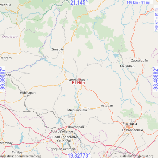
El Nith GPS coordinates[2]
20° 29' 16.008" North, 99° 11' 30.984" West
| Map corner | latitude | longitude |
|---|---|---|
| Upper-left | 21.145°, | -99.89507° |
| Center: | 20.48778°, | -99.19194° |
| Lower-right: | 19.82773°, | -98.48882° |
| Map W x H: | 146.5×146.5 km | = 91×91mi |
| max Lat: | 32.7° ⇑32.5% North |
| El Nith: | 20.48778° |
| min Lat: | ⇓67.5% South 14.53588° |
| min Long | El Nith | max Long |
| -117.105° | -99.19194° | -86.73105° |
| W 47.4%⇐ | ⇒52.6% E |
Elevation
Elevation of El Nith is 1751 m = 5745 ft, and this is 497.3 m = 1632 ft above average elevation for this country.
| Max E: |
3497 m = 11473 ft | 38.4% |
| El Nith | 1751 m 5745 ft | |
| Avg. | 1253.7 m = 4113 ft | |
Min E: |
-1 m = -3 ft | 61.6% |
See also: Mexico elevation on elevation.city.
Geographical zone
El Nith is located in North Torrid zone (between Equator and Tropic of Cancer). Distance of this Northern Tropic circle is 327.9 km =203.7 mi to North.| Distance of | km | miles | from El Nith |
|---|---|---|---|
| North Pole | 7729 | 4802.6 | to North |
| Arctic Circle | 5123.1 | 3183.3 | to North |
| Tropic Cancer | 327.9 | 203.7 | to North |
| Equator | 2278 | 1415.5 | to South |


Nearby cities:
15 places around El Nith: (largest is in red/bold)
• Arenalito Remedios
2.5 km =1.6 mi,  32°
32°
• Bangandhó
4.5 km =2.8 mi,  97°
97°
• Cantinela
3.8 km =2.4 mi,  209°
209°
• Colonia General Felipe Ángeles
1.2 km =0.7 mi,  345°
345°
• Colonia el Mirador
3.4 km =2.1 mi,  73°
73°
• Colonia la Libertad
1.4 km =0.9 mi,  16°
16°
• Dios Padre
2.7 km =1.7 mi,  200°
200°
• El Barrido
4.2 km =2.6 mi,  178°
178°
• El Carrizal
1.8 km =1.1 mi,  313°
313°
• El Tephé
4.7 km =2.9 mi,  157°
157°
• Ixmiquilpan
2.8 km =1.7 mi,  248°
248°
• La Estación
2.9 km =1.8 mi, 70°
• La Heredad
5 km =3.1 mi,  303°
303°
• Pueblo Nuevo
4.5 km =2.8 mi,  143°
143°
• San Pedro Capula
4.6 km =2.9 mi,  51°
51°
Sources, notices
• [Note1] Compared only with cities in Mexico existing in our database
• [Src1] Map data: © OpenStreetMap contributors (CC-BY-SA)
• [Src2] Other city data from geonames.org with taken over terms of usage.
• [Src3] Geographical zone / Annual Mean Temperature by Robert A. Rohde @ Wikipedia
