El Tephé geodata
El Tephé (Hidalgo) is a populated place; located in Mexico in America/Mexico_City (GMT-6) time zone. With population of 2,690 people, there are 3294 cities with bigger population in this country. Compared to other cities in Mexico, 66.7% of cities are located further ↓South; 52.3% of cities are located further →East and 61.7% of cities have lower elevation than El Tephé. Note1


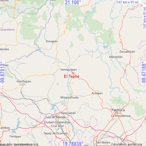
El Tephé GPS coordinates[2]
20° 26' 54.996" North, 99° 10' 30" West
| Map corner | latitude | longitude |
|---|---|---|
| Upper-left | 21.106°, | -99.87813° |
| Center: | 20.44861°, | -99.175° |
| Lower-right: | 19.78839°, | -98.47188° |
| Map W x H: | 146.5×146.5 km | = 91×91mi |
| max Lat: | 32.7° ⇑33.3% North |
| El Tephé: | 20.44861° |
| min Lat: | ⇓66.7% South 14.53588° |
| min Long | El Tephé | max Long |
| -117.105° | -99.175° | -86.73105° |
| W 47.7%⇐ | ⇒52.3% E |
Elevation
Elevation of El Tephé is 1754 m = 5755 ft, and this is 500.3 m = 1641 ft above average elevation for this country.
| Max E: |
3497 m = 11473 ft | 38.3% |
| El Tephé | 1754 m 5755 ft | |
| Avg. | 1253.7 m = 4113 ft | |
Min E: |
-1 m = -3 ft | 61.7% |
See also: Mexico elevation on elevation.city.
Geographical zone
El Tephé is located in North Torrid zone (between Equator and Tropic of Cancer). Distance of this Northern Tropic circle is 332.2 km =206.4 mi to North.| Distance of | km | miles | from El Tephé |
|---|---|---|---|
| North Pole | 7733.4 | 4805.3 | to North |
| Arctic Circle | 5127.5 | 3186.1 | to North |
| Tropic Cancer | 332.2 | 206.4 | to North |
| Equator | 2273.7 | 1412.8 | to South |


Nearby cities:
15 places around El Tephé: (largest is in red/bold)
• Bangandhó
4.7 km =2.9 mi,  35°
35°
• Cantinela
3.8 km =2.4 mi,  285°
285°
• Cañada Chica
4.4 km =2.7 mi,  152°
152°
• Colonia el Mirador
5.5 km =3.4 mi,  15°
15°
• Colonia la Libertad
5.8 km =3.6 mi,  346°
346°
• Dios Padre
3.3 km =2.1 mi,  303°
303°
• El Barrido
1.7 km =1.1 mi,  276°
276°
• El Nith
4.7 km =2.9 mi,  337°
337°
• El Tablón
3.5 km =2.2 mi,  203°
203°
• El Xothi
5 km =3.1 mi,  177°
177°
• Ixmiquilpan
5.5 km =3.4 mi,  307°
307°
• La Estación
5.4 km =3.4 mi,  10°
10°
• Maguey Blanco
2.8 km =1.7 mi,  170°
170°
• Pueblo Nuevo
1.1 km =0.7 mi,  50°
50°
• Taxadho
3.2 km =2 mi,  122°
122°
Sources, notices
• [Note1] Compared only with cities in Mexico existing in our database
• [Src1] Map data: © OpenStreetMap contributors (CC-BY-SA)
• [Src2] Other city data from geonames.org with taken over terms of usage.
• [Src3] Geographical zone / Annual Mean Temperature by Robert A. Rohde @ Wikipedia
