Vixtha de Madero geodata
Vixtha de Madero (Hidalgo) is a populated place; located in Mexico in America/Mexico_City (GMT-6) time zone. With population of 531 people, there are 15939 cities with bigger population in this country. Compared to other cities in Mexico, 63% of cities are located further ↓South; 50.4% of cities are located further →East and 72.3% of cities have lower elevation than Vixtha de Madero. Note1


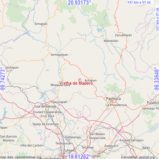
Vixtha de Madero GPS coordinates[2]
20° 16' 24.888" North, 99° 2' 22.56" West
| Map corner | latitude | longitude |
|---|---|---|
| Upper-left | 20.93173°, | -99.74273° |
| Center: | 20.27358°, | -99.0396° |
| Lower-right: | 19.61262°, | -98.33648° |
| Map W x H: | 146.7×146.7 km | = 91.2×91.2mi |
| max Lat: | 32.7° ⇑37% North |
| Vixtha de Madero: | 20.27358° |
| min Lat: | ⇓63% South 14.53588° |
| min Long | Vixtha de Mader | max Long |
| -117.105° | -99.0396° | -86.73105° |
| W 49.6%⇐ | ⇒50.4% E |
Elevation
Elevation of Vixtha de Madero is 1974 m = 6476 ft, and this is 720.3 m = 2363 ft above average elevation for this country.
| Max E: |
3497 m = 11473 ft | 27.7% |
| Vixtha de Madero | 1974 m 6476 ft | |
| Avg. | 1253.7 m = 4113 ft | |
Min E: |
-1 m = -3 ft | 72.3% |
See also: Mexico elevation on elevation.city.
Geographical zone
Vixtha de Madero is located in North Torrid zone (between Equator and Tropic of Cancer). Distance of this Northern Tropic circle is 351.7 km =218.5 mi to North.| Distance of | km | miles | from Vixtha de Madero |
|---|---|---|---|
| North Pole | 7752.9 | 4817.4 | to North |
| Arctic Circle | 5147 | 3198.2 | to North |
| Tropic Cancer | 351.7 | 218.5 | to North |
| Equator | 2254.2 | 1400.7 | to South |


Nearby cities:
15 places around Vixtha de Madero: (largest is in red/bold)
• Bocaja
3.2 km =2 mi,  97°
97°
• Bocamiño
4.8 km =3 mi,  223°
223°
• Bominthza
5 km =3.1 mi,  39°
39°
• Cañada Grande
5.8 km =3.6 mi, 36°
• Demacú
3.6 km =2.2 mi,  15°
15°
• El Bondho
3.9 km =2.4 mi,  69°
69°
• El Olvera
1.5 km =0.9 mi,  105°
105°
• El Rosario
3.2 km =2 mi,  152°
152°
• La Comunidad
4.7 km =2.9 mi,  233°
233°
• Pacheco
1.7 km =1.1 mi, 229°
• Poxindeje de Morelos
4.5 km =2.8 mi, 96°
• San Antonio Zaragoza
4.8 km =3 mi,  115°
115°
• San Miguel Acambay
1.6 km =1 mi,  280°
280°
• San Salvador
2.9 km =1.8 mi,  62°
62°
• Teofani
5.5 km =3.4 mi,  356°
356°
Sources, notices
• [Note1] Compared only with cities in Mexico existing in our database
• [Src1] Map data: © OpenStreetMap contributors (CC-BY-SA)
• [Src2] Other city data from geonames.org with taken over terms of usage.
• [Src3] Geographical zone / Annual Mean Temperature by Robert A. Rohde @ Wikipedia
