Cardonal geodata
Cardonal (Hidalgo) is a populated place; located in Mexico in America/Mexico_City (GMT-6) time zone. With population of 9,090 people, there are 1039 cities with bigger population in this country. Compared to other cities in Mexico, 58.2% of cities are located further ↓South; 53.3% of cities are located further →East and 78.9% of cities have lower elevation than Cardonal. Note1


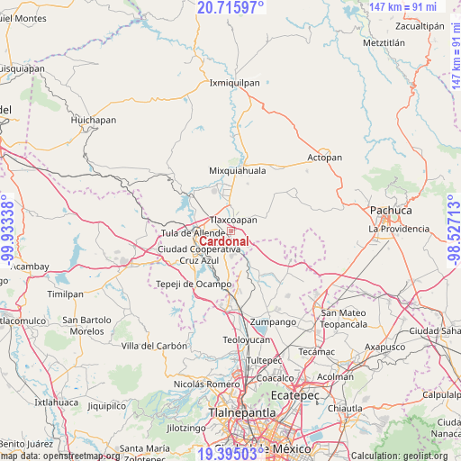
Cardonal GPS coordinates[2]
20° 3' 24.804" North, 99° 13' 48.9" West
| Map corner | latitude | longitude |
|---|---|---|
| Upper-left | 20.71597°, | -99.93338° |
| Center: | 20.05689°, | -99.23025° |
| Lower-right: | 19.39503°, | -98.52713° |
| Map W x H: | 146.9×146.9 km | = 91.3×91.3mi |
| max Lat: | 32.7° ⇑41.8% North |
| Cardonal: | 20.05689° |
| min Lat: | ⇓58.2% South 14.53588° |
| min Long | Cardonal | max Long |
| -117.105° | -99.23025° | -86.73105° |
| W 46.7%⇐ | ⇒53.3% E |
Elevation
Elevation of Cardonal is 2112 m = 6929 ft, and this is 858.3 m = 2816 ft above average elevation for this country.
| Max E: |
3497 m = 11473 ft | 21.1% |
| Cardonal | 2112 m 6929 ft | |
| Avg. | 1253.7 m = 4113 ft | |
Min E: |
-1 m = -3 ft | 78.9% |
See also: Mexico elevation on elevation.city.
Geographical zone
Cardonal is located in North Torrid zone (between Equator and Tropic of Cancer). Distance of this Northern Tropic circle is 375.8 km =233.5 mi to North.| Distance of | km | miles | from Cardonal |
|---|---|---|---|
| North Pole | 7776.9 | 4832.3 | to North |
| Arctic Circle | 5171.1 | 3213.2 | to North |
| Tropic Cancer | 375.8 | 233.5 | to North |
| Equator | 2230.1 | 1385.7 | to South |


Nearby cities:
15 places around Cardonal: (largest is in red/bold)
• Atitalaquia
1 km =0.6 mi,  71°
71°
• Atotonilco de Tula
5.6 km =3.5 mi,  166°
166°
• Bomintzha
6.5 km =4 mi,  222°
222°
• Cañada
6.6 km =4.1 mi,  188°
188°
• Doxey
4.1 km =2.5 mi,  340°
340°
• Ocampo
5.4 km =3.4 mi, 190°
• Progreso
4.2 km =2.6 mi, 191°
• Teocalco
6.4 km =4 mi,  300°
300°
• Texas
5 km =3.1 mi,  133°
133°
• Tezoquipa
2.7 km =1.7 mi,  91°
91°
• Tlalminulpa
2.2 km =1.4 mi,  22°
22°
• Tlamaco (San Gerónimo Tlamaco)
2.5 km =1.6 mi,  177°
177°
• Tlaxcoapan
4 km =2.5 mi,  14°
14°
• Unidad Habitacional Antonio Osorio de León (Bojay)
2.1 km =1.3 mi,  226°
226°
• Zacamulpa
6.3 km =3.9 mi,  206°
206°
Sources, notices
• [Note1] Compared only with cities in Mexico existing in our database
• [Src1] Map data: © OpenStreetMap contributors (CC-BY-SA)
• [Src2] Other city data from geonames.org with taken over terms of usage.
• [Src3] Geographical zone / Annual Mean Temperature by Robert A. Rohde @ Wikipedia
