El Tepeyac geodata
El Tepeyac (Hidalgo) is a populated place; located in Mexico in America/Mexico_City (GMT-6) time zone. With population of 1,602 people, there are 5396 cities with bigger population in this country. Compared to other cities in Mexico, 58% of cities are located further ↓South; 59.7% of cities are located further ←West and 85.6% of cities have lower elevation than El Tepeyac. Note1


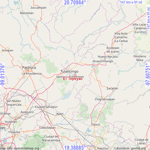
El Tepeyac GPS coordinates[2]
20° 3' 2.628" North, 98° 18' 38.268" West
| Map corner | latitude | longitude |
|---|---|---|
| Upper-left | 20.70984°, | -99.01376° |
| Center: | 20.05073°, | -98.31063° |
| Lower-right: | 19.38885°, | -97.60751° |
| Map W x H: | 146.9×146.9 km | = 91.3×91.3mi |
| max Lat: | 32.7° ⇑42% North |
| El Tepeyac: | 20.05073° |
| min Lat: | ⇓58% South 14.53588° |
| min Long | El Tepeyac | max Long |
| -117.105° | -98.31063° | -86.73105° |
| W 59.7%⇐ | ⇒40.3% E |
Elevation
Elevation of El Tepeyac is 2270 m = 7448 ft, and this is 1016.3 m = 3334 ft above average elevation for this country.
| Max E: |
3497 m = 11473 ft | 14.4% |
| El Tepeyac | 2270 m 7448 ft | |
| Avg. | 1253.7 m = 4113 ft | |
Min E: |
-1 m = -3 ft | 85.6% |
See also: Mexico elevation on elevation.city.
Geographical zone
El Tepeyac is located in North Torrid zone (between Equator and Tropic of Cancer). Distance of this Northern Tropic circle is 376.5 km =233.9 mi to North.| Distance of | km | miles | from El Tepeyac |
|---|---|---|---|
| North Pole | 7777.6 | 4832.8 | to North |
| Arctic Circle | 5171.7 | 3213.5 | to North |
| Tropic Cancer | 376.5 | 233.9 | to North |
| Equator | 2229.4 | 1385.3 | to South |


Nearby cities:
15 places around El Tepeyac: (largest is in red/bold)
• Almoloya
3.2 km =2 mi,  191°
191°
• Buenos Aires
3.8 km =2.4 mi,  149°
149°
• Cerro Verde
1.8 km =1.1 mi,  74°
74°
• Cuautepec de Hinojosa
1.7 km =1.1 mi,  178°
178°
• El Capulín
5.9 km =3.7 mi,  142°
142°
• Guadalupe Victoria
4.6 km =2.9 mi,  108°
108°
• Loma Bonita
0.8 km =0.5 mi,  34°
34°
• San Juan Hueyapan
3.8 km =2.4 mi,  127°
127°
• Santa María Nativitas
2.1 km =1.3 mi, 129°
• Santiago Tulantepec
5 km =3.1 mi,  251°
251°
• Texcaltepec
2.7 km =1.7 mi,  211°
211°
• Tezoquipa
3.3 km =2.1 mi,  233°
233°
• Tulancingo
6.6 km =4.1 mi,  303°
303°
• Ventoquipa
3.4 km =2.1 mi,  236°
236°
• Viveros de la Loma
6.4 km =4 mi,  331°
331°
Sources, notices
• [Note1] Compared only with cities in Mexico existing in our database
• [Src1] Map data: © OpenStreetMap contributors (CC-BY-SA)
• [Src2] Other city data from geonames.org with taken over terms of usage.
• [Src3] Geographical zone / Annual Mean Temperature by Robert A. Rohde @ Wikipedia
