San Lorenzo Sayula geodata
San Lorenzo Sayula (Hidalgo) is a populated place; located in Mexico in America/Mexico_City (GMT-6) time zone. With population of 2,300 people, there are 3834 cities with bigger population in this country. Compared to other cities in Mexico, 56.8% of cities are located further ↓South; 59.9% of cities are located further ←West and 88.6% of cities have lower elevation than San Lorenzo Sayula. Note1


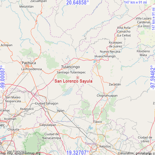
San Lorenzo Sayula GPS coordinates[2]
19° 59' 21.156" North, 98° 17' 51.864" West
| Map corner | latitude | longitude |
|---|---|---|
| Upper-left | 20.64858°, | -99.00087° |
| Center: | 19.98921°, | -98.29774° |
| Lower-right: | 19.32707°, | -97.59462° |
| Map W x H: | 146.9×146.9 km | = 91.3×91.3mi |
| max Lat: | 32.7° ⇑43.2% North |
| San Lorenzo Sayula: | 19.98921° |
| min Lat: | ⇓56.8% South 14.53588° |
| min Long | San Lorenzo Say | max Long |
| -117.105° | -98.29774° | -86.73105° |
| W 59.9%⇐ | ⇒40.1% E |
Elevation
Elevation of San Lorenzo Sayula is 2360 m = 7743 ft, and this is 1106.3 m = 3630 ft above average elevation for this country.
| Max E: |
3497 m = 11473 ft | 11.4% |
| San Lorenzo Sayula | 2360 m 7743 ft | |
| Avg. | 1253.7 m = 4113 ft | |
Min E: |
-1 m = -3 ft | 88.6% |
See also: Mexico elevation on elevation.city.
Geographical zone
San Lorenzo Sayula is located in North Torrid zone (between Equator and Tropic of Cancer). Distance of this Northern Tropic circle is 383.3 km =238.2 mi to North.| Distance of | km | miles | from San Lorenzo Sayula |
|---|---|---|---|
| North Pole | 7784.5 | 4837.1 | to North |
| Arctic Circle | 5178.6 | 3217.8 | to North |
| Tropic Cancer | 383.3 | 238.2 | to North |
| Equator | 2222.6 | 1381.1 | to South |


Nearby cities:
15 places around San Lorenzo Sayula: (largest is in red/bold)
• Almoloya
4.2 km =2.6 mi,  332°
332°
• Buenos Aires
3.6 km =2.2 mi,  9°
9°
• Cerro Verde
7.4 km =4.6 mi,  3°
3°
• Cuautepec de Hinojosa
5.3 km =3.3 mi,  345°
345°
• El Aserradero
4.8 km =3 mi,  217°
217°
• El Capulín
3.2 km =2 mi,  45°
45°
• El Tepeyac
7 km =4.3 mi, 348°
• Guadalupe Victoria
6.2 km =3.9 mi,  29°
29°
• San Juan Hueyapan
4.8 km =3 mi,  19°
19°
• Santa Elena Paliseca
6 km =3.7 mi,  80°
80°
• Santa María Nativitas
5.5 km =3.4 mi, 2°
• Texcaltepec
5.3 km =3.3 mi, 328°
• Tezoncualpan
3.5 km =2.2 mi,  137°
137°
• Tezoquipa
6.3 km =3.9 mi,  320°
320°
• Ventoquipa
6.5 km =4 mi, 319°
Sources, notices
• [Note1] Compared only with cities in Mexico existing in our database
• [Src1] Map data: © OpenStreetMap contributors (CC-BY-SA)
• [Src2] Other city data from geonames.org with taken over terms of usage.
• [Src3] Geographical zone / Annual Mean Temperature by Robert A. Rohde @ Wikipedia
