San Ildefonso geodata
San Ildefonso (Hidalgo) is a populated place; located in Mexico in America/Mexico_City (GMT-6) time zone. With population of 4,423 people, there are 2077 cities with bigger population in this country. Compared to other cities in Mexico, 56.9% of cities are located further ↓South; 55.2% of cities are located further →East and 82.7% of cities have lower elevation than San Ildefonso. Note1


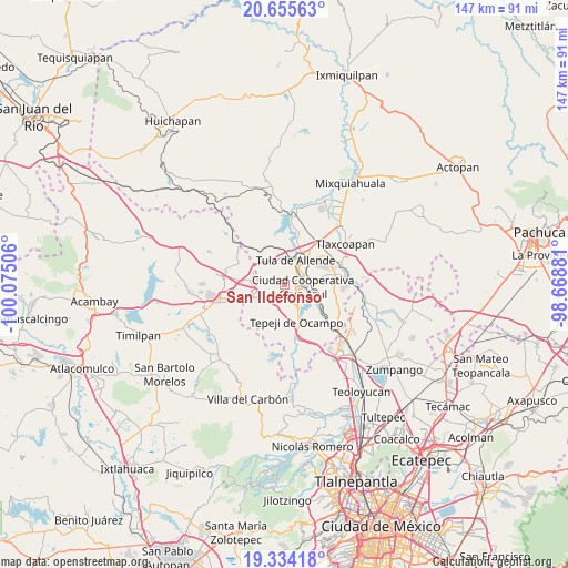
San Ildefonso GPS coordinates[2]
19° 59' 46.644" North, 99° 22' 18.948" West
| Map corner | latitude | longitude |
|---|---|---|
| Upper-left | 20.65563°, | -100.07506° |
| Center: | 19.99629°, | -99.37193° |
| Lower-right: | 19.33418°, | -98.66881° |
| Map W x H: | 146.9×146.9 km | = 91.3×91.3mi |
| max Lat: | 32.7° ⇑43.1% North |
| San Ildefonso: | 19.99629° |
| min Lat: | ⇓56.9% South 14.53588° |
| min Long | San Ildefonso | max Long |
| -117.105° | -99.37193° | -86.73105° |
| W 44.8%⇐ | ⇒55.2% E |
Elevation
Elevation of San Ildefonso is 2206 m = 7238 ft, and this is 952.3 m = 3124 ft above average elevation for this country.
| Max E: |
3497 m = 11473 ft | 17.3% |
| San Ildefonso | 2206 m 7238 ft | |
| Avg. | 1253.7 m = 4113 ft | |
Min E: |
-1 m = -3 ft | 82.7% |
See also: Mexico elevation on elevation.city.
Geographical zone
San Ildefonso is located in North Torrid zone (between Equator and Tropic of Cancer). Distance of this Northern Tropic circle is 382.5 km =237.7 mi to North.| Distance of | km | miles | from San Ildefonso |
|---|---|---|---|
| North Pole | 7783.7 | 4836.6 | to North |
| Arctic Circle | 5177.8 | 3217.3 | to North |
| Tropic Cancer | 382.5 | 237.7 | to North |
| Equator | 2223.4 | 1381.6 | to South |


Nearby cities:
15 places around San Ildefonso: (largest is in red/bold)
• Cañada de Madero
4.1 km =2.5 mi,  213°
213°
• Colonia Nueva Santa María
2.2 km =1.4 mi,  85°
85°
• Colonia Sesenta y Dos
2.9 km =1.8 mi,  69°
69°
• Ignacio Zaragoza
5.7 km =3.5 mi, 67°
• La Amistad
5.6 km =3.5 mi,  76°
76°
• Monte Alegre
3.5 km =2.2 mi,  115°
115°
• Nantzha
6.3 km =3.9 mi,  3°
3°
• San Andrés
6.5 km =4 mi,  352°
352°
• San Lucas Teacalco
2.1 km =1.3 mi,  145°
145°
• San Marcos
5.4 km =3.4 mi,  44°
44°
• San Miguel Vindho
5.7 km =3.5 mi, 92°
• Santa Ana Azcapotzaltongo
6.1 km =3.8 mi,  195°
195°
• Santa María Ilucan
3.4 km =2.1 mi,  97°
97°
• Santa María Magdalena
2.5 km =1.6 mi,  184°
184°
• Santiago Tlautla
3.8 km =2.4 mi, 175°
Sources, notices
• [Note1] Compared only with cities in Mexico existing in our database
• [Src1] Map data: © OpenStreetMap contributors (CC-BY-SA)
• [Src2] Other city data from geonames.org with taken over terms of usage.
• [Src3] Geographical zone / Annual Mean Temperature by Robert A. Rohde @ Wikipedia
