San Marcos geodata
San Marcos (Hidalgo) is a populated place; located in Mexico in America/Mexico_City (GMT-6) time zone. With population of 12,779 people, there are 764 cities with bigger population in this country. Compared to other cities in Mexico, 57.6% of cities are located further ↓South; 54.6% of cities are located further →East and 76% of cities have lower elevation than San Marcos. Note1


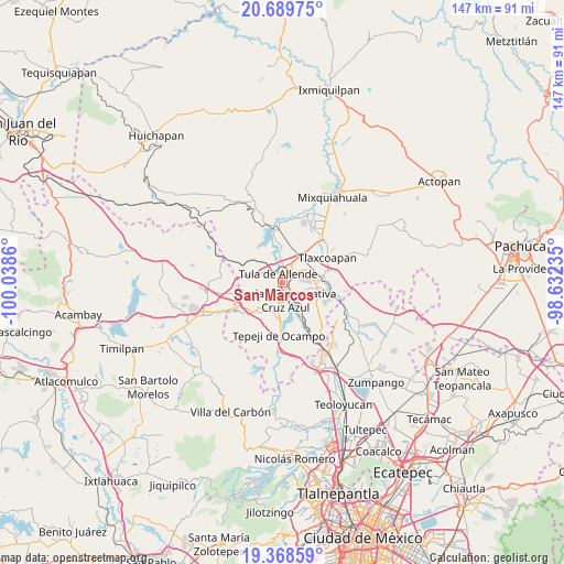
San Marcos GPS coordinates[2]
20° 1' 50.016" North, 99° 20' 7.692" West
| Map corner | latitude | longitude |
|---|---|---|
| Upper-left | 20.68975°, | -100.0386° |
| Center: | 20.03056°, | -99.33547° |
| Lower-right: | 19.36859°, | -98.63235° |
| Map W x H: | 146.9×146.9 km | = 91.3×91.3mi |
| max Lat: | 32.7° ⇑42.4% North |
| San Marcos: | 20.03056° |
| min Lat: | ⇓57.6% South 14.53588° |
| min Long | San Marcos | max Long |
| -117.105° | -99.33547° | -86.73105° |
| W 45.4%⇐ | ⇒54.6% E |
Elevation
Elevation of San Marcos is 2048 m = 6719 ft, and this is 794.3 m = 2606 ft above average elevation for this country.
| Max E: |
3497 m = 11473 ft | 24% |
| San Marcos | 2048 m 6719 ft | |
| Avg. | 1253.7 m = 4113 ft | |
Min E: |
-1 m = -3 ft | 76% |
See also: Mexico elevation on elevation.city.
Geographical zone
San Marcos is located in North Torrid zone (between Equator and Tropic of Cancer). Distance of this Northern Tropic circle is 378.7 km =235.3 mi to North.| Distance of | km | miles | from San Marcos |
|---|---|---|---|
| North Pole | 7779.9 | 4834.2 | to North |
| Arctic Circle | 5174 | 3215 | to North |
| Tropic Cancer | 378.7 | 235.3 | to North |
| Equator | 2227.2 | 1383.9 | to South |


Nearby cities:
15 places around San Marcos: (largest is in red/bold)
• Colonia Nueva Santa María
4 km =2.5 mi,  204°
204°
• Colonia Sesenta y Dos
3 km =1.9 mi, 201°
• El Crestón
4.7 km =2.9 mi,  316°
316°
• El Llano
4.2 km =2.6 mi,  22°
22°
• Ignacio Zaragoza
2.2 km =1.4 mi,  137°
137°
• La Amistad
2.9 km =1.8 mi,  147°
147°
• Monte Alegre
5.4 km =3.4 mi,  186°
186°
• Nantzha
4.3 km =2.7 mi,  306°
306°
• Residencial Arboledas
5.2 km =3.2 mi,  43°
43°
• San Andrés
5.4 km =3.4 mi,  299°
299°
• San Ildefonso
5.4 km =3.4 mi,  224°
224°
• San Lucas Teacalco
6.1 km =3.8 mi,  205°
205°
• San Miguel Vindho
4.4 km =2.7 mi,  155°
155°
• Santa María Ilucan
4.3 km =2.7 mi, 185°
• Tula de Allende
2.5 km =1.6 mi,  339°
339°
Sources, notices
• [Note1] Compared only with cities in Mexico existing in our database
• [Src1] Map data: © OpenStreetMap contributors (CC-BY-SA)
• [Src2] Other city data from geonames.org with taken over terms of usage.
• [Src3] Geographical zone / Annual Mean Temperature by Robert A. Rohde @ Wikipedia
