Guadalupe Cuauhtémoc geodata
Guadalupe Cuauhtémoc (Tlaxcala) is a populated place; located in Mexico in America/Mexico_City (GMT-6) time zone. With population of 560 people, there are 15231 cities with bigger population in this country. Compared to other cities in Mexico, 53.7% of cities are located further ↑North; 60.7% of cities are located further ←West and 92.7% of cities have lower elevation than Guadalupe Cuauhtémoc. Note1
Current local time in Guadalupe Cuauhtémoc:
05:36 AM, WednesdayDifference from your time zone: hours


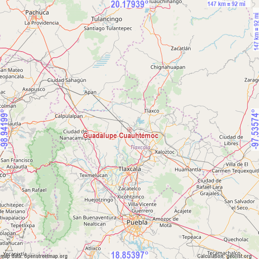
Guadalupe Cuauhtémoc GPS coordinates[2]
19° 31' 4.944" North, 98° 14' 19.896" West
| Map corner | latitude | longitude |
|---|---|---|
| Upper-left | 20.17939°, | -98.94199° |
| Center: | 19.51804°, | -98.23886° |
| Lower-right: | 18.85397°, | -97.53574° |
| Map W x H: | 147.4×147.4 km | = 91.6×91.6mi |
| max Lat: | 32.7° ⇑53.7% North |
| Guadalupe Cuauhtémoc: | 19.51804° |
| min Lat: | ⇓46.3% South 14.53588° |
| min Long | Guadalupe Cuauh | max Long |
| -117.105° | -98.23886° | -86.73105° |
| W 60.7%⇐ | ⇒39.3% E |
Elevation
Elevation of Guadalupe Cuauhtémoc is 2517 m = 8258 ft, and this is 1263.3 m = 4145 ft above average elevation for this country.
| Max E: |
3497 m = 11473 ft | 7.3% |
| Guadalupe Cuauhtémoc | 2517 m 8258 ft | |
| Avg. | 1253.7 m = 4113 ft | |
Min E: |
-1 m = -3 ft | 92.7% |
See also: Mexico elevation on elevation.city.
Geographical zone
Guadalupe Cuauhtémoc is located in North Torrid zone (between Equator and Tropic of Cancer). Distance of this Northern Tropic circle is 435.7 km =270.7 mi to North.| Distance of | km | miles | from Guadalupe Cuauhtémoc |
|---|---|---|---|
| North Pole | 7836.9 | 4869.6 | to North |
| Arctic Circle | 5231 | 3250.4 | to North |
| Tropic Cancer | 435.7 | 270.7 | to North |
| Equator | 2170.2 | 1348.5 | to South |


Nearby cities:
15 places around Guadalupe Cuauhtémoc: (largest is in red/bold)
• Atexcatzingo
11.1 km =6.9 mi,  119°
119°
• Atlangatepec
3.5 km =2.2 mi,  63°
63°
• Barrio de Cuatla
8.6 km =5.3 mi,  163°
163°
• José María Morelos
10.2 km =6.3 mi, 124°
• La Magdalena Soltepec
10.5 km =6.5 mi,  311°
311°
• Muñoz
5.7 km =3.5 mi,  147°
147°
• San José Cuamantzingo
1.6 km =1 mi,  259°
259°
• San José Tepeyahualco
9.6 km =6 mi,  340°
340°
• San Lucas Tecopilco
4 km =2.5 mi,  207°
207°
• San Pedro Ecatepec
8.8 km =5.5 mi,  87°
87°
• San Simeón Xipetzingo
7.1 km =4.4 mi,  233°
233°
• Santa Bárbara Acuicultzcatepec
8.2 km =5.1 mi,  169°
169°
• Santiago Tlalpan
8.7 km =5.4 mi,  238°
238°
• Xaltocan
10.8 km =6.7 mi, 163°
• Zumpango
4.7 km =2.9 mi,  19°
19°
Sources, notices
• [Note1] Compared only with cities in Mexico existing in our database
• [Src1] Map data: © OpenStreetMap contributors (CC-BY-SA)
• [Src2] Other city data from geonames.org with taken over terms of usage.
• [Src3] Geographical zone / Annual Mean Temperature by Robert A. Rohde @ Wikipedia
