Zumpango geodata
Zumpango (Tlaxcala) is a populated place; located in Mexico in America/Mexico_City (GMT-6) time zone. With population of 1,304 people, there are 6654 cities with bigger population in this country. Compared to other cities in Mexico, 52.9% of cities are located further ↑North; 60.9% of cities are located further ←West and 95.4% of cities have lower elevation than Zumpango. Note1


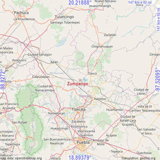
Zumpango GPS coordinates[2]
19° 33' 27.72" North, 98° 13' 26.652" West
| Map corner | latitude | longitude |
|---|---|---|
| Upper-left | 20.21888°, | -98.9272° |
| Center: | 19.5577°, | -98.22407° |
| Lower-right: | 18.89379°, | -97.52095° |
| Map W x H: | 147.3×147.3 km | = 91.5×91.5mi |
| max Lat: | 32.7° ⇑52.9% North |
| Zumpango: | 19.5577° |
| min Lat: | ⇓47.1% South 14.53588° |
| min Long | Zumpango | max Long |
| -117.105° | -98.22407° | -86.73105° |
| W 60.9%⇐ | ⇒39.1% E |
Elevation
Elevation of Zumpango is 2605 m = 8547 ft, and this is 1351.3 m = 4433 ft above average elevation for this country.
| Max E: |
3497 m = 11473 ft | 4.6% |
| Zumpango | 2605 m 8547 ft | |
| Avg. | 1253.7 m = 4113 ft | |
Min E: |
-1 m = -3 ft | 95.4% |
See also: Mexico elevation on elevation.city.
Geographical zone
Zumpango is located in North Torrid zone (between Equator and Tropic of Cancer). Distance of this Northern Tropic circle is 431.3 km =268 mi to North.| Distance of | km | miles | from Zumpango |
|---|---|---|---|
| North Pole | 7832.4 | 4866.8 | to North |
| Arctic Circle | 5226.6 | 3247.7 | to North |
| Tropic Cancer | 431.3 | 268 | to North |
| Equator | 2174.6 | 1351.2 | to South |


Nearby cities:
15 places around Zumpango: (largest is in red/bold)
• Atlangatepec
3.3 km =2.1 mi,  150°
150°
• Casa Blanca
11.8 km =7.3 mi,  351°
351°
• El Rosario
11.5 km =7.1 mi,  357°
357°
• Guadalupe Cuauhtémoc
4.7 km =2.9 mi,  199°
199°
• José María Morelos
12.3 km =7.6 mi, 146°
• La Magdalena Soltepec
9.7 km =6 mi,  285°
285°
• Lagunilla
10.2 km =6.3 mi,  328°
328°
• Muñoz
9.4 km =5.8 mi,  170°
170°
• San José Cuamantzingo
5.6 km =3.5 mi,  213°
213°
• San José Tepeyahualco
6.6 km =4.1 mi,  314°
314°
• San Lorenzo Sóltepec
10.7 km =6.6 mi,  298°
298°
• San Lucas Tecopilco
8.6 km =5.3 mi, 202°
• San Pedro Ecatepec
8.3 km =5.2 mi,  118°
118°
• San Simeón Xipetzingo
11.2 km =7 mi,  219°
219°
• Santa Bárbara Acuicultzcatepec
12.4 km =7.7 mi,  179°
179°
Sources, notices
• [Note1] Compared only with cities in Mexico existing in our database
• [Src1] Map data: © OpenStreetMap contributors (CC-BY-SA)
• [Src2] Other city data from geonames.org with taken over terms of usage.
• [Src3] Geographical zone / Annual Mean Temperature by Robert A. Rohde @ Wikipedia
