Lázaro Cárdenas geodata
Lázaro Cárdenas (Tlaxcala) is a populated place; located in Mexico in America/Mexico_City (GMT-6) time zone. With population of 1,242 people, there are 6984 cities with bigger population in this country. Compared to other cities in Mexico, 57.4% of cities are located further ↑North; 63.7% of cities are located further ←West and 92.9% of cities have lower elevation than Lázaro Cárdenas. Note1


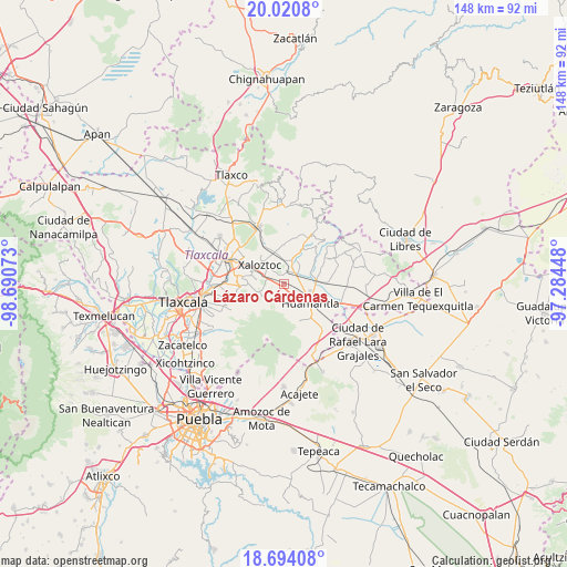
Lázaro Cárdenas GPS coordinates[2]
19° 21' 31.644" North, 97° 59' 15.36" West
| Map corner | latitude | longitude |
|---|---|---|
| Upper-left | 20.0208°, | -98.69073° |
| Center: | 19.35879°, | -97.9876° |
| Lower-right: | 18.69408°, | -97.28448° |
| Map W x H: | 147.5×147.5 km | = 91.7×91.7mi |
| max Lat: | 32.7° ⇑57.4% North |
| Lázaro Cárdenas: | 19.35879° |
| min Lat: | ⇓42.6% South 14.53588° |
| min Long | Lázaro Cárden | max Long |
| -117.105° | -97.9876° | -86.73105° |
| W 63.7%⇐ | ⇒36.3% E |
Elevation
Elevation of Lázaro Cárdenas is 2525 m = 8284 ft, and this is 1271.3 m = 4171 ft above average elevation for this country.
| Max E: |
3497 m = 11473 ft | 7.1% |
| Lázaro Cárdenas | 2525 m 8284 ft | |
| Avg. | 1253.7 m = 4113 ft | |
Min E: |
-1 m = -3 ft | 92.9% |
See also: Mexico elevation on elevation.city.
Geographical zone
Lázaro Cárdenas is located in North Torrid zone (between Equator and Tropic of Cancer). Distance of this Northern Tropic circle is 453.4 km =281.7 mi to North.| Distance of | km | miles | from Lázaro Cárdenas |
|---|---|---|---|
| North Pole | 7854.6 | 4880.6 | to North |
| Arctic Circle | 5248.7 | 3261.4 | to North |
| Tropic Cancer | 453.4 | 281.7 | to North |
| Equator | 2152.5 | 1337.5 | to South |


Nearby cities:
15 places around Lázaro Cárdenas: (largest is in red/bold)
• Benito Juárez
8.4 km =5.2 mi,  78°
78°
• Colonia Cuauhtémoc
3.8 km =2.4 mi,  141°
141°
• Colonia Velazco
8.4 km =5.2 mi,  340°
340°
• Colonia Venustiano Carranza
8.7 km =5.4 mi,  301°
301°
• El Carmen Xalpatlahuaya
3.7 km =2.3 mi,  9°
9°
• Huamantla
8.2 km =5.1 mi,  126°
126°
• José María Morelos
4.7 km =2.9 mi,  167°
167°
• Nicolás Bravo
7.3 km =4.5 mi,  16°
16°
• San José Teacalco
8.5 km =5.3 mi,  252°
252°
• San Juan Quetzalcoapan
9.1 km =5.7 mi,  284°
284°
• San Miguel Buenavista
9.1 km =5.7 mi,  266°
266°
• San Pedro Tlacotepec
7.4 km =4.6 mi, 303°
• Santa Cruz Zacatzontetla
6.6 km =4.1 mi,  311°
311°
• Tocatlán
5.3 km =3.3 mi, 308°
• Xaloztoc
8.2 km =5.1 mi, 311°
Sources, notices
• [Note1] Compared only with cities in Mexico existing in our database
• [Src1] Map data: © OpenStreetMap contributors (CC-BY-SA)
• [Src2] Other city data from geonames.org with taken over terms of usage.
• [Src3] Geographical zone / Annual Mean Temperature by Robert A. Rohde @ Wikipedia
