Zacatelco geodata
Zacatelco (Tlaxcala) is a populated place; located in Mexico in America/Mexico_City (GMT-6) time zone. With population of 38,466 people, there are 271 cities with bigger population in this country. Compared to other cities in Mexico, 60.8% of cities are located further ↑North; 60.6% of cities are located further ←West and 83.2% of cities have lower elevation than Zacatelco. Note1


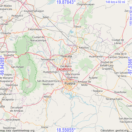
Zacatelco GPS coordinates[2]
19° 12' 56.988" North, 98° 14' 22.992" West
| Map corner | latitude | longitude |
|---|---|---|
| Upper-left | 19.87843°, | -98.94285° |
| Center: | 19.21583°, | -98.23972° |
| Lower-right: | 18.55055°, | -97.5366° |
| Map W x H: | 147.6×147.6 km | = 91.7×91.7mi |
| max Lat: | 32.7° ⇑60.8% North |
| Zacatelco: | 19.21583° |
| min Lat: | ⇓39.2% South 14.53588° |
| min Long | Zacatelco | max Long |
| -117.105° | -98.23972° | -86.73105° |
| W 60.6%⇐ | ⇒39.4% E |
Elevation
Elevation of Zacatelco is 2223 m = 7293 ft, and this is 969.3 m = 3180 ft above average elevation for this country.
| Max E: |
3497 m = 11473 ft | 16.8% |
| Zacatelco | 2223 m 7293 ft | |
| Avg. | 1253.7 m = 4113 ft | |
Min E: |
-1 m = -3 ft | 83.2% |
See also: Mexico elevation on elevation.city.
Geographical zone
Zacatelco is located in North Torrid zone (between Equator and Tropic of Cancer). Distance of this Northern Tropic circle is 469.3 km =291.6 mi to North.| Distance of | km | miles | from Zacatelco |
|---|---|---|---|
| North Pole | 7870.5 | 4890.5 | to North |
| Arctic Circle | 5264.6 | 3271.3 | to North |
| Tropic Cancer | 469.3 | 291.6 | to North |
| Equator | 2136.6 | 1327.6 | to South |


Nearby cities:
15 places around Zacatelco: (largest is in red/bold)
• Acuamanala
4.2 km =2.6 mi,  78°
78°
• Ayometitla
5 km =3.1 mi,  101°
101°
• Concepción Chimalpa
4.4 km =2.7 mi,  89°
89°
• El Carmen Aztama
2.6 km =1.6 mi,  54°
54°
• La Aurora
4.9 km =3 mi,  20°
20°
• San Cosme Atlamaxac
2.9 km =1.8 mi,  31°
31°
• San Jerónimo Zacualpan
3.6 km =2.2 mi,  320°
320°
• San Juan Huactzinco
2.4 km =1.5 mi,  325°
325°
• San Lorenzo Axocomanitla
1.3 km =0.8 mi,  313°
313°
• San Marcos Contla
4.6 km =2.9 mi,  113°
113°
• San Pedro Xalcaltzinco
1.8 km =1.1 mi,  42°
42°
• Santa Catarina Ayometla
3.4 km =2.1 mi,  125°
125°
• Santa Cruz Quilehtla
1.9 km =1.2 mi, 91°
• Tepeyanco
3.4 km =2.1 mi,  10°
10°
• Xicohtzinco
4.7 km =2.9 mi,  172°
172°
Sources, notices
• [Note1] Compared only with cities in Mexico existing in our database
• [Src1] Map data: © OpenStreetMap contributors (CC-BY-SA)
• [Src2] Other city data from geonames.org with taken over terms of usage.
• [Src3] Geographical zone / Annual Mean Temperature by Robert A. Rohde @ Wikipedia
