Ayometitla geodata
Ayometitla (Tlaxcala) is a populated place; located in Mexico in America/Mexico_City (GMT-6) time zone. With population of 1,841 people, there are 4720 cities with bigger population in this country. Compared to other cities in Mexico, 61% of cities are located further ↑North; 61.4% of cities are located further ←West and 87.5% of cities have lower elevation than Ayometitla. Note1


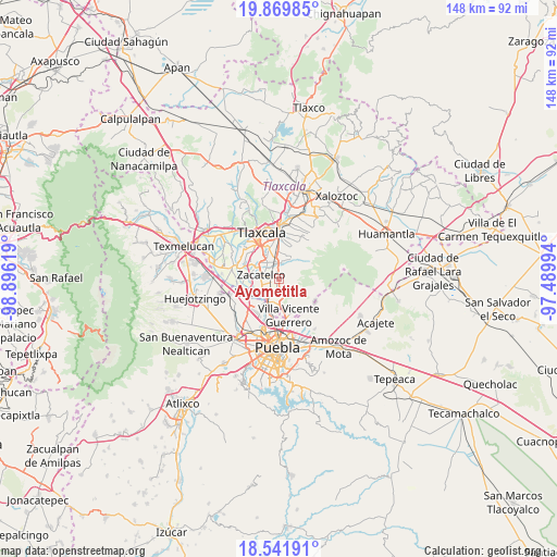
Ayometitla GPS coordinates[2]
19° 12' 25.992" North, 98° 11' 35.016" West
| Map corner | latitude | longitude |
|---|---|---|
| Upper-left | 19.86985°, | -98.89619° |
| Center: | 19.20722°, | -98.19306° |
| Lower-right: | 18.54191°, | -97.48994° |
| Map W x H: | 147.7×147.7 km | = 91.8×91.8mi |
| max Lat: | 32.7° ⇑61% North |
| Ayometitla: | 19.20722° |
| min Lat: | ⇓39% South 14.53588° |
| min Long | Ayometitla | max Long |
| -117.105° | -98.19306° | -86.73105° |
| W 61.4%⇐ | ⇒38.6% E |
Elevation
Elevation of Ayometitla is 2327 m = 7635 ft, and this is 1073.3 m = 3521 ft above average elevation for this country.
| Max E: |
3497 m = 11473 ft | 12.5% |
| Ayometitla | 2327 m 7635 ft | |
| Avg. | 1253.7 m = 4113 ft | |
Min E: |
-1 m = -3 ft | 87.5% |
See also: Mexico elevation on elevation.city.
Geographical zone
Ayometitla is located in North Torrid zone (between Equator and Tropic of Cancer). Distance of this Northern Tropic circle is 470.3 km =292.2 mi to North.| Distance of | km | miles | from Ayometitla |
|---|---|---|---|
| North Pole | 7871.4 | 4891.1 | to North |
| Arctic Circle | 5265.5 | 3271.8 | to North |
| Tropic Cancer | 470.3 | 292.2 | to North |
| Equator | 2135.6 | 1327 | to South |


Nearby cities:
15 places around Ayometitla: (largest is in red/bold)
• Acuamanala
2 km =1.2 mi,  336°
336°
• Concepción Chimalpa
1.1 km =0.7 mi,  332°
332°
• Cuaxinca
5.2 km =3.2 mi,  37°
37°
• El Carmen Aztama
3.7 km =2.3 mi,  312°
312°
• Guadalupe Hidalgo
2.2 km =1.4 mi,  15°
15°
• Mazatecochco
3.2 km =2 mi,  168°
168°
• Olextla de Juárez
0.7 km =0.4 mi, 23°
• Papalotla
4.4 km =2.7 mi,  194°
194°
• San Cosme Atlamaxac
4.8 km =3 mi,  315°
315°
• San Marcos Contla
1.1 km =0.7 mi,  217°
217°
• San Pedro Xalcaltzinco
4.3 km =2.7 mi,  301°
301°
• Santa Catarina Ayometla
2.4 km =1.5 mi,  245°
245°
• Santa Cruz Quilehtla
3.1 km =1.9 mi,  286°
286°
• Teolocholco
4 km =2.5 mi,  3°
3°
• Zacatelco
5 km =3.1 mi,  281°
281°
Sources, notices
• [Note1] Compared only with cities in Mexico existing in our database
• [Src1] Map data: © OpenStreetMap contributors (CC-BY-SA)
• [Src2] Other city data from geonames.org with taken over terms of usage.
• [Src3] Geographical zone / Annual Mean Temperature by Robert A. Rohde @ Wikipedia
