San Miguel Analco geodata
San Miguel Analco (Puebla) is a populated place; located in Mexico in America/Mexico_City (GMT-6) time zone. With population of 1,482 people, there are 5820 cities with bigger population in this country. Compared to other cities in Mexico, 61.6% of cities are located further ↑North; 59.4% of cities are located further ←West and 82.5% of cities have lower elevation than San Miguel Analco. Note1


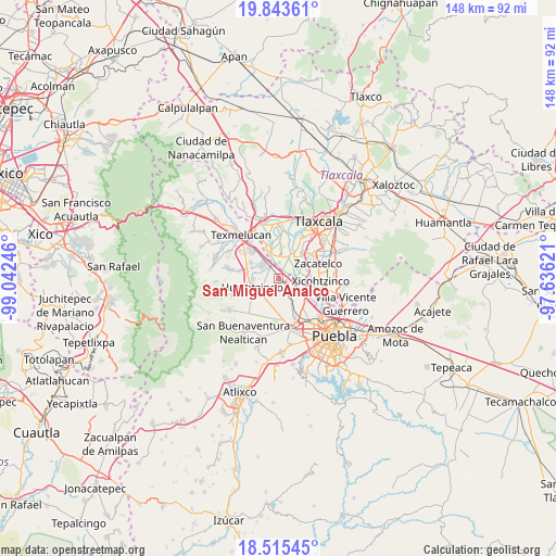
San Miguel Analco GPS coordinates[2]
19° 10' 51.132" North, 98° 20' 21.588" West
| Map corner | latitude | longitude |
|---|---|---|
| Upper-left | 19.84361°, | -99.04246° |
| Center: | 19.18087°, | -98.33933° |
| Lower-right: | 18.51545°, | -97.63621° |
| Map W x H: | 147.7×147.7 km | = 91.8×91.8mi |
| max Lat: | 32.7° ⇑61.6% North |
| San Miguel Analco: | 19.18087° |
| min Lat: | ⇓38.4% South 14.53588° |
| min Long | San Miguel Anal | max Long |
| -117.105° | -98.33933° | -86.73105° |
| W 59.4%⇐ | ⇒40.6% E |
Elevation
Elevation of San Miguel Analco is 2200 m = 7218 ft, and this is 946.3 m = 3105 ft above average elevation for this country.
| Max E: |
3497 m = 11473 ft | 17.5% |
| San Miguel Analco | 2200 m 7218 ft | |
| Avg. | 1253.7 m = 4113 ft | |
Min E: |
-1 m = -3 ft | 82.5% |
See also: Mexico elevation on elevation.city.
Geographical zone
San Miguel Analco is located in North Torrid zone (between Equator and Tropic of Cancer). Distance of this Northern Tropic circle is 473.2 km =294 mi to North.| Distance of | km | miles | from San Miguel Analco |
|---|---|---|---|
| North Pole | 7874.3 | 4892.9 | to North |
| Arctic Circle | 5268.5 | 3273.7 | to North |
| Tropic Cancer | 473.2 | 294 | to North |
| Equator | 2132.7 | 1325.2 | to South |


Nearby cities:
15 places around San Miguel Analco: (largest is in red/bold)
• Guadalupe Victoria
5.8 km =3.6 mi,  4°
4°
• Jesús Tepactepec
6 km =3.7 mi,  26°
26°
• Los Encinos
6.2 km =3.9 mi,  268°
268°
• Natívitas
6.4 km =4 mi,  23°
23°
• San Antonio Mihuacán
4.8 km =3 mi,  130°
130°
• San Miguel Xochitecatitla
6.6 km =4.1 mi,  346°
346°
• San Miguel Xoxtla
3.6 km =2.2 mi,  113°
113°
• San Miguel del Milagro
6.7 km =4.2 mi,  5°
5°
• Santa Ana Portales
4.5 km =2.8 mi,  61°
61°
• Santa Ana Xalmimilulco
5.7 km =3.5 mi,  308°
308°
• Santa Apolonia Teacalco
7.3 km =4.5 mi, 23°
• Santa María Zacatepec
7 km =4.3 mi,  203°
203°
• Santiago Michac
4.3 km =2.7 mi, 0°
• Santo Tomás la Concordia
5.8 km =3.6 mi, 21°
• Tlaltenango
1 km =0.6 mi,  188°
188°
Sources, notices
• [Note1] Compared only with cities in Mexico existing in our database
• [Src1] Map data: © OpenStreetMap contributors (CC-BY-SA)
• [Src2] Other city data from geonames.org with taken over terms of usage.
• [Src3] Geographical zone / Annual Mean Temperature by Robert A. Rohde @ Wikipedia
