San Miguel Xoxtla geodata
San Miguel Xoxtla (Puebla) is a populated place; located in Mexico in America/Mexico_City (GMT-6) time zone. With population of 11,269 people, there are 847 cities with bigger population in this country. Compared to other cities in Mexico, 61.8% of cities are located further ↑North; 59.8% of cities are located further ←West and 82.5% of cities have lower elevation than San Miguel Xoxtla. Note1


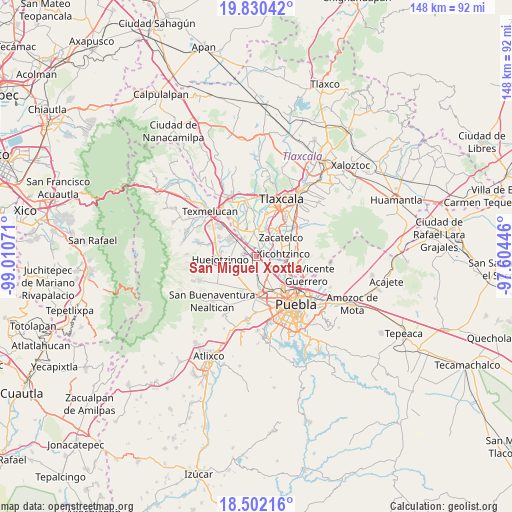
San Miguel Xoxtla GPS coordinates[2]
19° 10' 3.468" North, 98° 18' 27.288" West
| Map corner | latitude | longitude |
|---|---|---|
| Upper-left | 19.83042°, | -99.01071° |
| Center: | 19.16763°, | -98.30758° |
| Lower-right: | 18.50216°, | -97.60446° |
| Map W x H: | 147.7×147.7 km | = 91.8×91.8mi |
| max Lat: | 32.7° ⇑61.8% North |
| San Miguel Xoxtla: | 19.16763° |
| min Lat: | ⇓38.2% South 14.53588° |
| min Long | San Miguel Xoxt | max Long |
| -117.105° | -98.30758° | -86.73105° |
| W 59.8%⇐ | ⇒40.2% E |
Elevation
Elevation of San Miguel Xoxtla is 2203 m = 7228 ft, and this is 949.3 m = 3115 ft above average elevation for this country.
| Max E: |
3497 m = 11473 ft | 17.5% |
| San Miguel Xoxtla | 2203 m 7228 ft | |
| Avg. | 1253.7 m = 4113 ft | |
Min E: |
-1 m = -3 ft | 82.5% |
See also: Mexico elevation on elevation.city.
Geographical zone
San Miguel Xoxtla is located in North Torrid zone (between Equator and Tropic of Cancer). Distance of this Northern Tropic circle is 474.7 km =295 mi to North.| Distance of | km | miles | from San Miguel Xoxtla |
|---|---|---|---|
| North Pole | 7875.8 | 4893.8 | to North |
| Arctic Circle | 5269.9 | 3274.6 | to North |
| Tropic Cancer | 474.7 | 295 | to North |
| Equator | 2131.2 | 1324.3 | to South |


Nearby cities:
15 places around San Miguel Xoxtla: (largest is in red/bold)
• Coronango
5.2 km =3.2 mi,  178°
178°
• Cuanalá
6.8 km =4.2 mi,  198°
198°
• Jesús Tepactepec
6.9 km =4.3 mi,  354°
354°
• Natívitas
7.3 km =4.5 mi, 354°
• San Antonio Mihuacán
1.6 km =1 mi,  169°
169°
• San Francisco Ocotlán
4.5 km =2.8 mi,  145°
145°
• San Jacinto
6.4 km =4 mi,  104°
104°
• San Miguel Analco
3.6 km =2.2 mi,  293°
293°
• Santa Ana Portales
3.7 km =2.3 mi,  9°
9°
• Santa María Zacatepec
7.8 km =4.8 mi,  230°
230°
• Santiago Michac
6.7 km =4.2 mi,  330°
330°
• Santo Tomás la Concordia
7 km =4.3 mi, 349°
• Tetlatlahuca
7.3 km =4.5 mi, 9°
• Tlaltenango
3.5 km =2.2 mi,  277°
277°
• Xicohtzinco
7.8 km =4.8 mi,  85°
85°
Sources, notices
• [Note1] Compared only with cities in Mexico existing in our database
• [Src1] Map data: © OpenStreetMap contributors (CC-BY-SA)
• [Src2] Other city data from geonames.org with taken over terms of usage.
• [Src3] Geographical zone / Annual Mean Temperature by Robert A. Rohde @ Wikipedia
