San José Pathuitz geodata
San José Pathuitz (Chiapas) is a populated place; located in Mexico in America/Mexico_City (GMT-6) time zone. With population of 598 people, there are 14373 cities with bigger population in this country. Compared to other cities in Mexico, 86.7% of cities are located further ↑North; 96% of cities are located further ←West and 71.6% of cities have higher elevation than San José Pathuitz. Note1


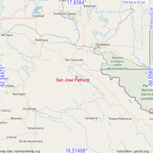
San José Pathuitz GPS coordinates[2]
17° 11' 16.476" North, 91° 39' 41.832" West
| Map corner | latitude | longitude |
|---|---|---|
| Upper-left | 17.8584°, | -92.36475° |
| Center: | 17.18791°, | -91.66162° |
| Lower-right: | 16.51498°, | -90.9585° |
| Map W x H: | 149.4×149.4 km | = 92.8×92.8mi |
| max Lat: | 32.7° ⇑86.7% North |
| San José Pathuitz: | 17.18791° |
| min Lat: | ⇓13.3% South 14.53588° |
| min Long | San José Pathu | max Long |
| -117.105° | -91.66162° | -86.73105° |
| W 96%⇐ | ⇒4% E |
Elevation
Elevation of San José Pathuitz is 343 m = 1125 ft, and this is 910.7 m = 2988 ft below average elevation for this country.
| Max E: |
3497 m = 11473 ft | 71.6% |
| Avg. | 1253.7 m = 4113 ft | |
| San José Pathuitz | 343 m = 1125 ft | |
Min E: |
-1 m = -3 ft | 28.4% |
See also: Mexico elevation on elevation.city.
Geographical zone
San José Pathuitz is located in North Torrid zone (between Equator and Tropic of Cancer). Distance of this Northern Tropic circle is 694.8 km =431.7 mi to North.| Distance of | km | miles | from San José Pathuitz |
|---|---|---|---|
| North Pole | 8095.9 | 5030.6 | to North |
| Arctic Circle | 5490.1 | 3411.4 | to North |
| Tropic Cancer | 694.8 | 431.7 | to North |
| Equator | 1911.1 | 1187.5 | to South |


Nearby cities:
15 places around San José Pathuitz: (largest is in red/bold)
• Cristóbal Colón
3.5 km =2.2 mi,  82°
82°
• Damasco
7.1 km =4.4 mi,  114°
114°
• El Diamante
8.9 km =5.5 mi,  226°
226°
• El Edén
14.5 km =9 mi,  49°
49°
• El Tumbo
12.8 km =8 mi,  162°
162°
• Jol Tulijá
5.4 km =3.4 mi,  251°
251°
• La Reforma de Ocampo
14.4 km =8.9 mi,  345°
345°
• Nueva Esperanza (La Esperanza)
8.7 km =5.4 mi,  190°
190°
• Nueva Samaria
5.4 km =3.4 mi, 79°
• Nuevo Jericó
14.1 km =8.8 mi,  116°
116°
• Nuevo San Joaquín
14.4 km =8.9 mi,  314°
314°
• Peña Limonar
8.9 km =5.5 mi,  213°
213°
• Río Chancalá
16.5 km =10.3 mi, 351°
• San Jerónimo Tulijá
14.2 km =8.8 mi,  286°
286°
• San Martín Chamizal
10.4 km =6.5 mi,  33°
33°
Sources, notices
• [Note1] Compared only with cities in Mexico existing in our database
• [Src1] Map data: © OpenStreetMap contributors (CC-BY-SA)
• [Src2] Other city data from geonames.org with taken over terms of usage.
• [Src3] Geographical zone / Annual Mean Temperature by Robert A. Rohde @ Wikipedia
